Westerborstel geodata
Westerborstel (Schleswig-Holstein) is a seat of a fourth-order administrative division; located in Germany in Europe/Berlin (GMT+2) time zone. With population of 95 people, there are 10853 cities with bigger population in this country. Compared to other cities in Germany, 95.5% of cities are located further ↓South; 61% of cities are located further →East and 99.1% of cities have higher elevation than Westerborstel. Note1
Administrative division(s):
- Level 1: Schleswig-Holstein
- Level 3: Kreis Dithmarschen
- Level 4: Westerborstel


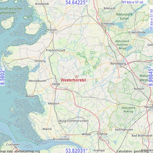
Westerborstel GPS coordinates[2]
54° 13' 59.988" North, 9° 16' 59.988" East
| Map corner | latitude | longitude |
|---|---|---|
| Upper-left | 54.64225°, | 8.5802° |
| Center: | 54.23333°, | 9.28333° |
| Lower-right: | 53.82031°, | 9.98645° |
| Map W x H: | 91.4×91.4 km | = 56.8×56.8mi |
| max Lat: | 55.01917° ⇑4.5% North |
| Westerborstel: | 54.23333° |
| min Lat: | ⇓95.5% South 47.40724° |
| min Long | Westerborstel | max Long |
| 5.92978° | 9.28333° | 14.98853° |
| W 39%⇐ | ⇒61% E |
Elevation
Elevation of Westerborstel is 0 m = 0 ft, and this is 249.1 m = 817 ft below average elevation for this country.
| Max E: |
1256 m = 4121 ft | 99.1% |
| Avg. | 249.1 m = 817 ft | |
| Westerborstel | 0 m = 0 ft | |
Min E: |
-5 m = -16 ft | 0.9% |
See also: Germany elevation on elevation.city.
Geographical zone
Westerborstel is located in North temperate zone (between Tropic of Cancer and the Arctic Circle). Distance of this North polar circle is 1371 km =851.9 mi to North.| Distance of | km | miles | from Westerborstel |
|---|---|---|---|
| North Pole | 3976.9 | 2471.1 | to North |
| Arctic Circle | 1371 | 851.9 | to North |
| Tropic Cancer | 3424.3 | 2127.8 | to South |
| Equator | 6030.2 | 3747 | to South |


Nearby cities:
15 places around Westerborstel: (largest is in red/bold)
• Barkenholm
6.5 km =4 mi,  270°
270°
• Dellstedt
5.4 km =3.4 mi,  90°
90°
• Dörpling
3.2 km =2 mi,  26°
26°
• Gaushorn
4.9 km =3 mi,  221°
221°
• Hövede
2.1 km =1.3 mi, 30°
• Immenstedt
5.7 km =3.5 mi,  168°
168°
• Osterrade
5.7 km =3.5 mi,  130°
130°
• Pahlen
3.9 km =2.4 mi,  16°
16°
• Schalkholz
2.2 km =1.4 mi,  311°
311°
• Schrum
6 km =3.7 mi,  201°
201°
• Süderdorf
4.7 km =2.9 mi,  113°
113°
• Tellingstedt
1.9 km =1.2 mi,  180°
180°
• Tielen
6.4 km =4 mi, 30°
• Wallen
5.7 km =3.5 mi,  348°
348°
• Welmbüttel
4.3 km =2.7 mi,  210°
210°
Sources, notices
• [Note1] Compared only with cities in Germany existing in our database
• [Src1] Map data: © OpenStreetMap contributors (CC-BY-SA)
• [Src2] Other city data from geonames.org with taken over terms of usage.
• [Src3] Geographical zone / Annual Mean Temperature by Robert A. Rohde @ Wikipedia
