Sankt Thomas geodata
Sankt Thomas (Rheinland-Pfalz) is a seat of a fourth-order administrative division; located in Germany in Europe/Berlin (GMT+2) time zone. With population of 320 people, there are 9983 cities with bigger population in this country. Compared to other cities in Germany, 62.2% of cities are located further ↑North; 97.1% of cities are located further →East and 60.2% of cities have lower elevation than Sankt Thomas. Note1
Administrative division(s):
- Level 1: Rheinland-Pfalz
- Level 3: Eifelkreis Bitburg-Prüm
- Level 4: Sankt Thomas


Sankt Thomas GPS coordinates[2]
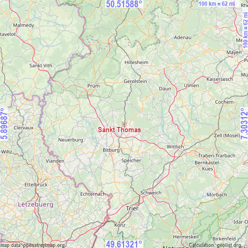
50° 4' 0.012" North, 6° 36' 0" East
| Map corner | latitude | longitude |
|---|---|---|
| Upper-left | 50.51588°, | 5.89687° |
| Center: | 50.06667°, | 6.6° |
| Lower-right: | 49.61321°, | 7.30312° |
| Map W x H: | 100.4×100.4 km | = 62.4×62.4mi |
| max Lat: | 55.01917° ⇑62.2% North |
| Sankt Thomas: | 50.06667° |
| min Lat: | ⇓37.8% South 47.40724° |
| min Long | Sankt Thomas | max Long |
| 5.92978° | 6.6° | 14.98853° |
| W 2.9%⇐ | ⇒97.1% E |
Elevation
Elevation of Sankt Thomas is 291 m = 955 ft, and this is 41.9 m = 137 ft above average elevation for this country.
| Max E: |
1256 m = 4121 ft | 39.8% |
| Sankt Thomas | 291 m 955 ft | |
| Avg. | 249.1 m = 817 ft | |
Min E: |
-5 m = -16 ft | 60.2% |
See also: Germany elevation on elevation.city.
Geographical zone
Sankt Thomas is located in North temperate zone (between Tropic of Cancer and the Arctic Circle). Distance of this North polar circle is 1834.3 km =1139.8 mi to North.| Distance of | km | miles | from Sankt Thomas |
|---|---|---|---|
| North Pole | 4440.2 | 2759 | to North |
| Arctic Circle | 1834.3 | 1139.8 | to North |
| Tropic Cancer | 2961 | 1839.9 | to South |
| Equator | 5566.9 | 3459.1 | to South |


Nearby cities:
15 places around Sankt Thomas: (largest is in red/bold)
• Balesfeld
6 km =3.7 mi,  307°
307°
• Etteldorf
4.4 km =2.7 mi,  212°
212°
• Kyllburg
3.1 km =1.9 mi,  186°
186°
• Kyllburgweiler
2.2 km =1.4 mi,  147°
147°
• Malberg
2.2 km =1.4 mi, 212°
• Malbergweich
3.5 km =2.2 mi,  248°
248°
• Neidenbach
5.1 km =3.2 mi,  316°
316°
• Neuheilenbach
6 km =3.7 mi,  336°
336°
• Orsfeld
3.9 km =2.4 mi,  162°
162°
• Sefferweich
5.9 km =3.7 mi,  270°
270°
• Seinsfeld
4 km =2.5 mi,  117°
117°
• Steinborn
2.4 km =1.5 mi,  90°
90°
• Usch
3.7 km =2.3 mi,  0°
0°
• Wilsecker
5.7 km =3.5 mi, 192°
• Zendscheid
3.7 km =2.3 mi, 0°
Sources, notices
• [Note1] Compared only with cities in Germany existing in our database
• [Src1] Map data: © OpenStreetMap contributors (CC-BY-SA)
• [Src2] Other city data from geonames.org with taken over terms of usage.
• [Src3] Geographical zone / Annual Mean Temperature by Robert A. Rohde @ Wikipedia
