Nitz geodata
Nitz (Rheinland-Pfalz) is a seat of a fourth-order administrative division; located in Germany in Europe/Berlin (GMT+2) time zone. With population of 45 people, there are 10973 cities with bigger population in this country. Compared to other cities in Germany, 56.1% of cities are located further ↑North; 93.2% of cities are located further →East and 79.9% of cities have lower elevation than Nitz. Note1


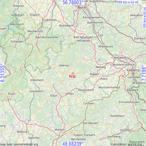
Nitz GPS coordinates[2]
50° 19' 59.988" North, 7° 1' 0.012" East
| Map corner | latitude | longitude |
|---|---|---|
| Upper-left | 50.78003°, | 6.31355° |
| Center: | 50.33333°, | 7.01667° |
| Lower-right: | 49.88239°, | 7.7198° |
| Map W x H: | 99.8×99.8 km | = 62×62mi |
| max Lat: | 55.01917° ⇑56.1% North |
| Nitz: | 50.33333° |
| min Lat: | ⇓43.9% South 47.40724° |
| min Long | Nitz | max Long |
| 5.92978° | 7.01667° | 14.98853° |
| W 6.8%⇐ | ⇒93.2% E |
Elevation
Elevation of Nitz is 432 m = 1417 ft, and this is 182.9 m = 600 ft above average elevation for this country.
| Max E: |
1256 m = 4121 ft | 20.1% |
| Nitz | 432 m 1417 ft | |
| Avg. | 249.1 m = 817 ft | |
Min E: |
-5 m = -16 ft | 79.9% |
See also: Germany elevation on elevation.city.
Geographical zone
Nitz is located in North temperate zone (between Tropic of Cancer and the Arctic Circle). Distance of this North polar circle is 1804.6 km =1121.3 mi to North.| Distance of | km | miles | from Nitz |
|---|---|---|---|
| North Pole | 4410.5 | 2740.6 | to North |
| Arctic Circle | 1804.6 | 1121.3 | to North |
| Tropic Cancer | 2990.6 | 1858.3 | to South |
| Equator | 5596.5 | 3477.5 | to South |


Nearby cities:
15 places around Nitz: (largest is in red/bold)
• Acht
5.1 km =3.2 mi,  43°
43°
• Boos
1.9 km =1.2 mi,  180°
180°
• Brücktal
3 km =1.9 mi,  231°
231°
• Ditscheid
5.1 km =3.2 mi,  136°
136°
• Drees
2.2 km =1.4 mi,  327°
327°
• Herresbach
3.7 km =2.3 mi,  0°
0°
• Kirsbach
1.2 km =0.7 mi,  270°
270°
• Lind
2.2 km =1.4 mi,  147°
147°
• Meuspath
4 km =2.5 mi,  297°
297°
• Münk
3.9 km =2.4 mi,  162°
162°
• Nachtsheim
4 km =2.5 mi,  117°
117°
• Nürburg
4.7 km =2.9 mi, 270°
• Virneburg
5.1 km =3.2 mi,  68°
68°
• Welcherath
4 km =2.5 mi,  242°
242°
• Welschenbach
5.1 km =3.2 mi, 43°
Sources, notices
• [Note1] Compared only with cities in Germany existing in our database
• [Src1] Map data: © OpenStreetMap contributors (CC-BY-SA)
• [Src2] Other city data from geonames.org with taken over terms of usage.
• [Src3] Geographical zone / Annual Mean Temperature by Robert A. Rohde @ Wikipedia
