Kretzschau geodata
Kretzschau (Saxony-Anhalt) is a seat of a fourth-order administrative division; located in Germany in Europe/Berlin (GMT+2) time zone. With population of 1,335 people, there are 6208 cities with bigger population in this country. Compared to other cities in Germany, 58.9% of cities are located further ↓South; 82.7% of cities are located further ←West and 54.4% of cities have higher elevation than Kretzschau. Note1


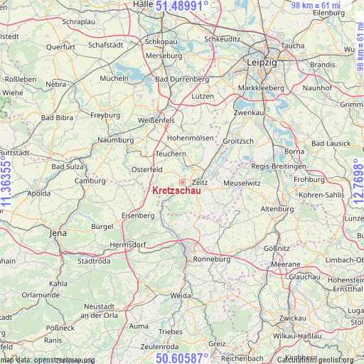
Kretzschau GPS coordinates[2]
51° 3' 0" North, 12° 4' 0.012" East
| Map corner | latitude | longitude |
|---|---|---|
| Upper-left | 51.48991°, | 11.36355° |
| Center: | 51.05°, | 12.06667° |
| Lower-right: | 50.60587°, | 12.7698° |
| Map W x H: | 98.3×98.3 km | = 61.1×61.1mi |
| max Lat: | 55.01917° ⇑41.1% North |
| Kretzschau: | 51.05° |
| min Lat: | ⇓58.9% South 47.40724° |
| min Long | Kretzschau | max Long |
| 5.92978° | 12.06667° | 14.98853° |
| W 82.7%⇐ | ⇒17.3% E |
Elevation
Elevation of Kretzschau is 194 m = 636 ft, and this is 55.1 m = 181 ft below average elevation for this country.
| Max E: |
1256 m = 4121 ft | 54.4% |
| Avg. | 249.1 m = 817 ft | |
| Kretzschau | 194 m = 636 ft | |
Min E: |
-5 m = -16 ft | 45.6% |
See also: Germany elevation on elevation.city.
Geographical zone
Kretzschau is located in North temperate zone (between Tropic of Cancer and the Arctic Circle). Distance of this North polar circle is 1724.9 km =1071.8 mi to North.| Distance of | km | miles | from Kretzschau |
|---|---|---|---|
| North Pole | 4330.8 | 2691 | to North |
| Arctic Circle | 1724.9 | 1071.8 | to North |
| Tropic Cancer | 3070.3 | 1907.8 | to South |
| Equator | 5676.2 | 3527 | to South |


Nearby cities:
15 places around Kretzschau: (largest is in red/bold)
• Deuben
6.6 km =4.1 mi,  3°
3°
• Droyßig
3 km =1.9 mi,  253°
253°
• Droßdorf
6 km =3.7 mi,  140°
140°
• Döschwitz
1.6 km =1 mi,  334°
334°
• Grana
2.8 km =1.7 mi,  79°
79°
• Gröben
8.4 km =5.2 mi,  348°
348°
• Haynsburg
3.5 km =2.2 mi,  180°
180°
• Luckenau
4.6 km =2.9 mi,  13°
13°
• Meineweh
6.3 km =3.9 mi,  298°
298°
• Nonnewitz
6.1 km =3.8 mi,  41°
41°
• Teuchern
8.4 km =5.2 mi,  339°
339°
• Theißen
5 km =3.1 mi,  33°
33°
• Trebnitz
4.9 km =3 mi,  359°
359°
• Wetterzeube
6.6 km =4.1 mi,  212°
212°
• Zeitz
4.9 km =3 mi,  90°
90°
Sources, notices
• [Note1] Compared only with cities in Germany existing in our database
• [Src1] Map data: © OpenStreetMap contributors (CC-BY-SA)
• [Src2] Other city data from geonames.org with taken over terms of usage.
• [Src3] Geographical zone / Annual Mean Temperature by Robert A. Rohde @ Wikipedia
