Kandern geodata
Kandern (Baden-Württemberg) is a populated place; located in Germany in Europe/Berlin (GMT+2) time zone. With population of 8,070 people, there are 1945 cities with bigger population in this country. Compared to other cities in Germany, 98.6% of cities are located further ↑North; 83.7% of cities are located further →East and 68.7% of cities have lower elevation than Kandern. Note1
Administrative division(s):
- Level 1: Baden-Württemberg
- Level 2: Freiburg Region
- Level 3: Landkreis Lörrach
- Level 4: Kandern


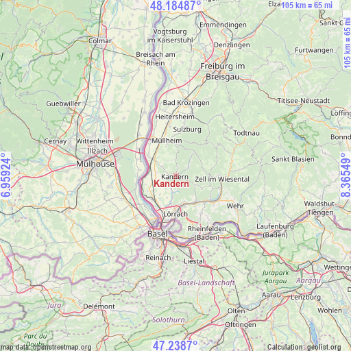
Kandern GPS coordinates[2]
47° 42' 50.148" North, 7° 39' 44.532" East
| Map corner | latitude | longitude |
|---|---|---|
| Upper-left | 48.18487°, | 6.95924° |
| Center: | 47.71393°, | 7.66237° |
| Lower-right: | 47.2387°, | 8.36549° |
| Map W x H: | 105.2×105.2 km | = 65.4×65.4mi |
| max Lat: | 55.01917° ⇑98.6% North |
| Kandern: | 47.71393° |
| min Lat: | ⇓1.4% South 47.40724° |
| min Long | Kandern | max Long |
| 5.92978° | 7.66237° | 14.98853° |
| W 16.3%⇐ | ⇒83.7% E |
Elevation
Elevation of Kandern is 348 m = 1142 ft, and this is 98.9 m = 324 ft above average elevation for this country.
| Max E: |
1256 m = 4121 ft | 31.3% |
| Kandern | 348 m 1142 ft | |
| Avg. | 249.1 m = 817 ft | |
Min E: |
-5 m = -16 ft | 68.7% |
See also: Germany elevation on elevation.city.
Geographical zone
Kandern is located in North temperate zone (between Tropic of Cancer and the Arctic Circle). Distance of this North polar circle is 2095.9 km =1302.3 mi to North.| Distance of | km | miles | from Kandern |
|---|---|---|---|
| North Pole | 4701.8 | 2921.6 | to North |
| Arctic Circle | 2095.9 | 1302.3 | to North |
| Tropic Cancer | 2699.4 | 1677.3 | to South |
| Equator | 5305.3 | 3296.6 | to South |


Nearby cities:
15 places around Kandern: (largest is in red/bold)
• Auggen
9 km =5.6 mi,  328°
328°
• Bad Bellingen
8.1 km =5 mi,  283°
283°
• Badenweiler
9.8 km =6.1 mi,  4°
4°
• Binzen
9.6 km =6 mi,  200°
200°
• Efringen-Kirchen
10.1 km =6.3 mi,  225°
225°
• Eimeldingen
10.1 km =6.3 mi,  207°
207°
• Feldberg
6.9 km =4.3 mi,  346°
346°
• Fischingen
8.5 km =5.3 mi, 213°
• Rümmingen
8.2 km =5.1 mi,  190°
190°
• Schallbach
7.4 km =4.6 mi, 197°
• Schliengen
8 km =5 mi,  306°
306°
• Steinen
9.6 km =6 mi,  143°
143°
• Wies
8.7 km =5.4 mi,  64°
64°
• Wieslet
10.5 km =6.5 mi,  105°
105°
• Wittlingen
6.6 km =4.1 mi, 187°
Sources, notices
• [Note1] Compared only with cities in Germany existing in our database
• [Src1] Map data: © OpenStreetMap contributors (CC-BY-SA)
• [Src2] Other city data from geonames.org with taken over terms of usage.
• [Src3] Geographical zone / Annual Mean Temperature by Robert A. Rohde @ Wikipedia
