Hupperath geodata
Hupperath (Rheinland-Pfalz) is a seat of a fourth-order administrative division; located in Germany in Europe/Berlin (GMT+2) time zone. With population of 596 people, there are 8852 cities with bigger population in this country. Compared to other cities in Germany, 63.8% of cities are located further ↑North; 95.3% of cities are located further →East and 68.2% of cities have lower elevation than Hupperath. Note1
Administrative division(s):
- Level 1: Rheinland-Pfalz
- Level 3: Landkreis Bernkastel-Wittlich
- Level 4: Hupperath


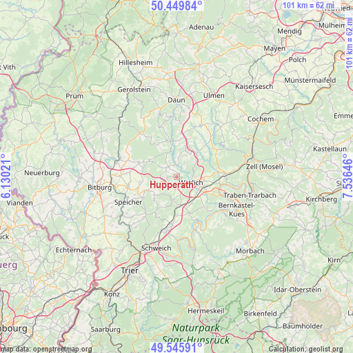
Hupperath GPS coordinates[2]
50° 0' 0" North, 6° 49' 59.988" East
| Map corner | latitude | longitude |
|---|---|---|
| Upper-left | 50.44984°, | 6.13021° |
| Center: | 50°, | 6.83333° |
| Lower-right: | 49.54591°, | 7.53646° |
| Map W x H: | 100.5×100.5 km | = 62.4×62.4mi |
| max Lat: | 55.01917° ⇑63.8% North |
| Hupperath: | 50° |
| min Lat: | ⇓36.2% South 47.40724° |
| min Long | Hupperath | max Long |
| 5.92978° | 6.83333° | 14.98853° |
| W 4.7%⇐ | ⇒95.3% E |
Elevation
Elevation of Hupperath is 344 m = 1129 ft, and this is 94.9 m = 311 ft above average elevation for this country.
| Max E: |
1256 m = 4121 ft | 31.8% |
| Hupperath | 344 m 1129 ft | |
| Avg. | 249.1 m = 817 ft | |
Min E: |
-5 m = -16 ft | 68.2% |
See also: Germany elevation on elevation.city.
Geographical zone
Hupperath is located in North temperate zone (between Tropic of Cancer and the Arctic Circle). Distance of this North polar circle is 1841.7 km =1144.4 mi to North.| Distance of | km | miles | from Hupperath |
|---|---|---|---|
| North Pole | 4447.6 | 2763.6 | to North |
| Arctic Circle | 1841.7 | 1144.4 | to North |
| Tropic Cancer | 2953.6 | 1835.3 | to South |
| Equator | 5559.5 | 3454.5 | to South |


Nearby cities:
15 places around Hupperath: (largest is in red/bold)
• Altrich
7.4 km =4.6 mi,  130°
130°
• Bergweiler
3.9 km =2.4 mi,  197°
197°
• Bruch
6 km =3.7 mi,  217°
217°
• Dreis
6.7 km =4.2 mi,  189°
189°
• Flußbach
7.4 km =4.6 mi,  75°
75°
• Gipperath
4.4 km =2.7 mi,  32°
32°
• Greimerath
6 km =3.7 mi,  52°
52°
• Großlittgen
4 km =2.5 mi,  321°
321°
• Karl
6 km =3.7 mi,  336°
336°
• Landscheid
5.1 km =3.2 mi,  248°
248°
• Minderlittgen
1.9 km =1.2 mi,  0°
0°
• Musweiler
2.6 km =1.6 mi,  296°
296°
• Plein
4.4 km =2.7 mi, 32°
• Schladt
3.7 km =2.3 mi, 0°
• Wittlich
4.5 km =2.8 mi,  110°
110°
Sources, notices
• [Note1] Compared only with cities in Germany existing in our database
• [Src1] Map data: © OpenStreetMap contributors (CC-BY-SA)
• [Src2] Other city data from geonames.org with taken over terms of usage.
• [Src3] Geographical zone / Annual Mean Temperature by Robert A. Rohde @ Wikipedia
