Großkampenberg geodata
Großkampenberg (Rheinland-Pfalz) is a seat of a fourth-order administrative division; located in Germany in Europe/Berlin (GMT+2) time zone. With population of 161 people, there are 10640 cities with bigger population in this country. Compared to other cities in Germany, 60.2% of cities are located further ↑North; 99.7% of cities are located further →East and 89.8% of cities have lower elevation than Großkampenberg. Note1
Administrative division(s):
- Level 1: Rheinland-Pfalz
- Level 3: Eifelkreis Bitburg-Prüm
- Level 4: Großkampenberg


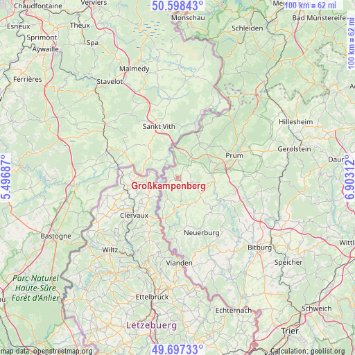
Großkampenberg GPS coordinates[2]
50° 9' 0" North, 6° 12' 0" East
| Map corner | latitude | longitude |
|---|---|---|
| Upper-left | 50.59843°, | 5.49687° |
| Center: | 50.15°, | 6.2° |
| Lower-right: | 49.69733°, | 6.90312° |
| Map W x H: | 100.2×100.2 km | = 62.3×62.3mi |
| max Lat: | 55.01917° ⇑60.2% North |
| Großkampenberg: | 50.15° |
| min Lat: | ⇓39.8% South 47.40724° |
| min Long | Großkampenberg | max Long |
| 5.92978° | 6.2° | 14.98853° |
| W 0.3%⇐ | ⇒99.7% E |
Elevation
Elevation of Großkampenberg is 512 m = 1680 ft, and this is 262.9 m = 863 ft above average elevation for this country.
| Max E: |
1256 m = 4121 ft | 10.2% |
| Großkampenberg | 512 m 1680 ft | |
| Avg. | 249.1 m = 817 ft | |
Min E: |
-5 m = -16 ft | 89.8% |
See also: Germany elevation on elevation.city.
Geographical zone
Großkampenberg is located in North temperate zone (between Tropic of Cancer and the Arctic Circle). Distance of this North polar circle is 1825 km =1134 mi to North.| Distance of | km | miles | from Großkampenberg |
|---|---|---|---|
| North Pole | 4430.9 | 2753.2 | to North |
| Arctic Circle | 1825 | 1134 | to North |
| Tropic Cancer | 2970.2 | 1845.6 | to South |
| Equator | 5576.2 | 3464.9 | to South |


Nearby cities:
15 places around Großkampenberg: (largest is in red/bold)
• Eschfeld
3.7 km =2.3 mi,  180°
180°
• Euscheid
7.4 km =4.6 mi,  104°
104°
• Habscheid
6 km =3.7 mi,  52°
52°
• Harspelt
3 km =1.9 mi,  232°
232°
• Heckhuscheid
3.6 km =2.2 mi,  26°
26°
• Herzfeld
2.2 km =1.4 mi,  147°
147°
• Kesfeld
2.4 km =1.5 mi,  90°
90°
• Leidenborn
2.2 km =1.4 mi, 147°
• Lützkampen
1.2 km =0.7 mi,  270°
270°
• Masthorn
7.1 km =4.4 mi, 90°
• Reiff
5.6 km =3.5 mi, 180°
• Reipeldingen
7.5 km =4.7 mi,  189°
189°
• Roscheid
3.9 km =2.4 mi,  197°
197°
• Sengerich
3.9 km =2.4 mi,  162°
162°
• Winterspelt
7.5 km =4.7 mi,  9°
9°
Sources, notices
• [Note1] Compared only with cities in Germany existing in our database
• [Src1] Map data: © OpenStreetMap contributors (CC-BY-SA)
• [Src2] Other city data from geonames.org with taken over terms of usage.
• [Src3] Geographical zone / Annual Mean Temperature by Robert A. Rohde @ Wikipedia
