Etgert geodata
Etgert (Rheinland-Pfalz) is a seat of a fourth-order administrative division; located in Germany in Europe/Berlin (GMT+2) time zone. With population of 62 people, there are 10936 cities with bigger population in this country. Compared to other cities in Germany, 69.5% of cities are located further ↑North; 93% of cities are located further →East and 81.7% of cities have lower elevation than Etgert. Note1
Administrative division(s):
- Level 1: Rheinland-Pfalz
- Level 3: Landkreis Bernkastel-Wittlich
- Level 4: Etgert


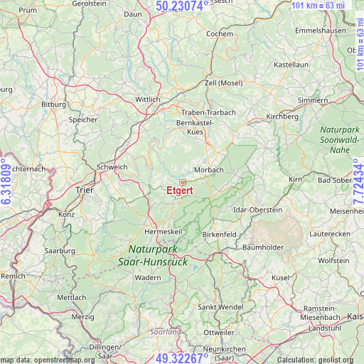
Etgert GPS coordinates[2]
49° 46' 43.788" North, 7° 1' 16.356" East
| Map corner | latitude | longitude |
|---|---|---|
| Upper-left | 50.23074°, | 6.31809° |
| Center: | 49.77883°, | 7.02121° |
| Lower-right: | 49.32267°, | 7.72434° |
| Map W x H: | 101×101 km | = 62.8×62.8mi |
| max Lat: | 55.01917° ⇑69.5% North |
| Etgert: | 49.77883° |
| min Lat: | ⇓30.5% South 47.40724° |
| min Long | Etgert | max Long |
| 5.92978° | 7.02121° | 14.98853° |
| W 7%⇐ | ⇒93% E |
Elevation
Elevation of Etgert is 444 m = 1457 ft, and this is 194.9 m = 639 ft above average elevation for this country.
| Max E: |
1256 m = 4121 ft | 18.3% |
| Etgert | 444 m 1457 ft | |
| Avg. | 249.1 m = 817 ft | |
Min E: |
-5 m = -16 ft | 81.7% |
See also: Germany elevation on elevation.city.
Geographical zone
Etgert is located in North temperate zone (between Tropic of Cancer and the Arctic Circle). Distance of this North polar circle is 1866.3 km =1159.7 mi to North.| Distance of | km | miles | from Etgert |
|---|---|---|---|
| North Pole | 4472.2 | 2778.9 | to North |
| Arctic Circle | 1866.3 | 1159.7 | to North |
| Tropic Cancer | 2929 | 1820 | to South |
| Equator | 5534.9 | 3439.2 | to South |


Nearby cities:
15 places around Etgert: (largest is in red/bold)
• Berglicht
4.1 km =2.5 mi,  283°
283°
• Burtscheid
7.2 km =4.5 mi,  225°
225°
• Deuselbach
3.8 km =2.4 mi,  147°
147°
• Gielert
1.4 km =0.9 mi,  249°
249°
• Gräfendhron
2.6 km =1.6 mi,  309°
309°
• Hilscheid
5.3 km =3.3 mi,  196°
196°
• Horath
4.4 km =2.7 mi,  324°
324°
• Immert
1.4 km =0.9 mi,  193°
193°
• Lückenburg
6.4 km =4 mi,  217°
217°
• Malborn
7.4 km =4.6 mi, 201°
• Merschbach
2.8 km =1.7 mi,  327°
327°
• Neunkirchen
6 km =3.7 mi,  237°
237°
• Rorodt
2.5 km =1.6 mi,  123°
123°
• Talling
5.3 km =3.3 mi,  255°
255°
• Thalfang
3.5 km =2.2 mi,  205°
205°
Sources, notices
• [Note1] Compared only with cities in Germany existing in our database
• [Src1] Map data: © OpenStreetMap contributors (CC-BY-SA)
• [Src2] Other city data from geonames.org with taken over terms of usage.
• [Src3] Geographical zone / Annual Mean Temperature by Robert A. Rohde @ Wikipedia
