Elisabeth-Sophien-Koog geodata
Elisabeth-Sophien-Koog (Schleswig-Holstein) is a seat of a fourth-order administrative division; located in Germany in Europe/Berlin (GMT+2) time zone. With population of 46 people, there are 10971 cities with bigger population in this country. Compared to other cities in Germany, 98.1% of cities are located further ↓South; 66.9% of cities are located further →East and 99.5% of cities have higher elevation than Elisabeth-Sophien-Koog. Note1
Administrative division(s):
- Level 1: Schleswig-Holstein
- Level 3: Kreis Nordfriesland
- Level 4: Elisabeth-Sophien-Koog
Current local time in Elisabeth-Sophien-Koog:
05:10 PM, TuesdayDifference from your time zone: hours


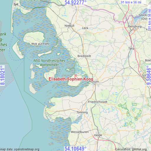
Elisabeth-Sophien-Koog GPS coordinates[2]
54° 31' 0.012" North, 8° 52' 59.988" East
| Map corner | latitude | longitude |
|---|---|---|
| Upper-left | 54.92277°, | 8.18021° |
| Center: | 54.51667°, | 8.88333° |
| Lower-right: | 54.10649°, | 9.58646° |
| Map W x H: | 90.8×90.8 km | = 56.4×56.4mi |
| max Lat: | 55.01917° ⇑1.9% North |
| Elisabeth-Sophien-Koog: | 54.51667° |
| min Lat: | ⇓98.1% South 47.40724° |
| min Long | Elisabeth-Sophi | max Long |
| 5.92978° | 8.88333° | 14.98853° |
| W 33.1%⇐ | ⇒66.9% E |
Elevation
Elevation of Elisabeth-Sophien-Koog is -1 m = -3 ft, and this is 250.1 m = 821 ft below average elevation for this country.
| Max E: |
1256 m = 4121 ft | 99.5% |
| Avg. | 249.1 m = 817 ft | |
| Elisabeth-Sophien-Koog | -1 m = -3 ft | |
Min E: |
-5 m = -16 ft | 0.5% |
See also: Germany elevation on elevation.city.
Geographical zone
Elisabeth-Sophien-Koog is located in North temperate zone (between Tropic of Cancer and the Arctic Circle). Distance of this North polar circle is 1339.5 km =832.3 mi to North.| Distance of | km | miles | from Elisabeth-Sophien-Koog |
|---|---|---|---|
| North Pole | 3945.4 | 2451.6 | to North |
| Arctic Circle | 1339.5 | 832.3 | to North |
| Tropic Cancer | 3455.8 | 2147.3 | to South |
| Equator | 6061.7 | 3766.6 | to South |


Nearby cities:
15 places around Elisabeth-Sophien-Koog: (largest is in red/bold)
• Ahrenshöft
12.4 km =7.7 mi,  72°
72°
• Almdorf
11.4 km =7.1 mi,  49°
49°
• Arlewatt
13 km =8.1 mi,  81°
81°
• Bredstedt
12.5 km =7.8 mi,  24°
24°
• Breklum
11.3 km =7 mi,  34°
34°
• Hattstedt
9.9 km =6.2 mi, 79°
• Hattstedtermarsch
8.4 km =5.2 mi,  63°
63°
• Horstedt
11.9 km =7.4 mi,  85°
85°
• Husum
11.4 km =7.1 mi,  107°
107°
• Reußenköge
9.6 km =6 mi,  7°
7°
• Schobüll
8 km =5 mi,  95°
95°
• Simonsberg
11 km =6.8 mi,  146°
146°
• Struckum
10.6 km =6.6 mi, 45°
• Uelvesbüll
11.6 km =7.2 mi,  166°
166°
• Wobbenbüll
7.8 km =4.8 mi, 76°
Sources, notices
• [Note1] Compared only with cities in Germany existing in our database
• [Src1] Map data: © OpenStreetMap contributors (CC-BY-SA)
• [Src2] Other city data from geonames.org with taken over terms of usage.
• [Src3] Geographical zone / Annual Mean Temperature by Robert A. Rohde @ Wikipedia
