Daubach geodata
Daubach (Rheinland-Pfalz) is a seat of a fourth-order administrative division; located in Germany in Europe/Berlin (GMT+2) time zone. With population of 245 people, there are 10278 cities with bigger population in this country. Compared to other cities in Germany, 67.8% of cities are located further ↑North; 84.4% of cities are located further →East and 72.3% of cities have lower elevation than Daubach. Note1
Administrative division(s):
- Level 1: Rheinland-Pfalz
- Level 3: Landkreis Bad Kreuznach
- Level 4: Daubach


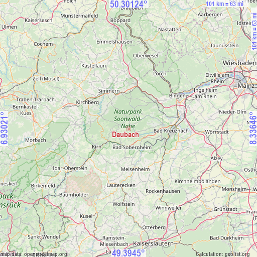
Daubach GPS coordinates[2]
49° 51' 0" North, 7° 37' 59.988" East
| Map corner | latitude | longitude |
|---|---|---|
| Upper-left | 50.30124°, | 6.93021° |
| Center: | 49.85°, | 7.63333° |
| Lower-right: | 49.3945°, | 8.33646° |
| Map W x H: | 100.8×100.8 km | = 62.6×62.6mi |
| max Lat: | 55.01917° ⇑67.8% North |
| Daubach: | 49.85° |
| min Lat: | ⇓32.2% South 47.40724° |
| min Long | Daubach | max Long |
| 5.92978° | 7.63333° | 14.98853° |
| W 15.6%⇐ | ⇒84.4% E |
Elevation
Elevation of Daubach is 376 m = 1234 ft, and this is 126.9 m = 416 ft above average elevation for this country.
| Max E: |
1256 m = 4121 ft | 27.7% |
| Daubach | 376 m 1234 ft | |
| Avg. | 249.1 m = 817 ft | |
Min E: |
-5 m = -16 ft | 72.3% |
See also: Germany elevation on elevation.city.
Geographical zone
Daubach is located in North temperate zone (between Tropic of Cancer and the Arctic Circle). Distance of this North polar circle is 1858.4 km =1154.8 mi to North.| Distance of | km | miles | from Daubach |
|---|---|---|---|
| North Pole | 4464.3 | 2774 | to North |
| Arctic Circle | 1858.4 | 1154.8 | to North |
| Tropic Cancer | 2936.9 | 1824.9 | to South |
| Equator | 5542.8 | 3444.1 | to South |


Nearby cities:
15 places around Daubach: (largest is in red/bold)
• Allenfeld
3 km =1.9 mi,  52°
52°
• Argenschwang
6 km =3.7 mi, 52°
• Auen
3 km =1.9 mi,  232°
232°
• Bockenau
4 km =2.5 mi,  117°
117°
• Burgsponheim
6.3 km =3.9 mi,  107°
107°
• Gebroth
3.9 km =2.4 mi,  17°
17°
• Ippenschied
1.9 km =1.2 mi,  0°
0°
• Langenthal
5.1 km =3.2 mi,  248°
248°
• Monzingen
6.5 km =4 mi,  206°
206°
• Nußbaum
5.7 km =3.5 mi,  192°
192°
• Rehbach
0 km =0 mi, 0°
• Seesbach
6.2 km =3.9 mi,  265°
265°
• Spall
5.2 km =3.2 mi,  44°
44°
• Winterbach
1.9 km =1.2 mi, 0°
• Winterburg
2.2 km =1.4 mi,  32°
32°
Sources, notices
• [Note1] Compared only with cities in Germany existing in our database
• [Src1] Map data: © OpenStreetMap contributors (CC-BY-SA)
• [Src2] Other city data from geonames.org with taken over terms of usage.
• [Src3] Geographical zone / Annual Mean Temperature by Robert A. Rohde @ Wikipedia
