Bliestorf geodata
Bliestorf (Schleswig-Holstein) is a seat of a fourth-order administrative division; located in Germany in Europe/Berlin (GMT+2) time zone. With population of 699 people, there are 8319 cities with bigger population in this country. Compared to other cities in Germany, 89.5% of cities are located further ↓South; 60.8% of cities are located further ←West and 91.2% of cities have higher elevation than Bliestorf. Note1
Administrative division(s):
- Level 1: Schleswig-Holstein
- Level 3: Kreis Herzogtum Lauenburg
- Level 4: Bliestorf


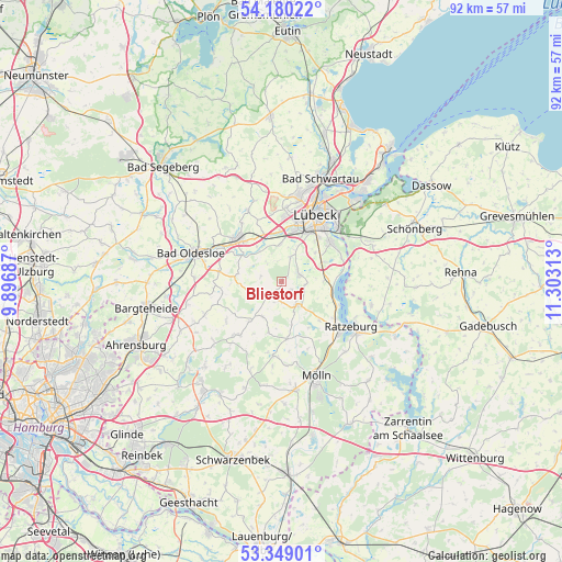
Bliestorf GPS coordinates[2]
53° 46' 0.012" North, 10° 36' 0" East
| Map corner | latitude | longitude |
|---|---|---|
| Upper-left | 54.18022°, | 9.89687° |
| Center: | 53.76667°, | 10.6° |
| Lower-right: | 53.34901°, | 11.30313° |
| Map W x H: | 92.4×92.4 km | = 57.4×57.4mi |
| max Lat: | 55.01917° ⇑10.5% North |
| Bliestorf: | 53.76667° |
| min Lat: | ⇓89.5% South 47.40724° |
| min Long | Bliestorf | max Long |
| 5.92978° | 10.6° | 14.98853° |
| W 60.8%⇐ | ⇒39.2% E |
Elevation
Elevation of Bliestorf is 18 m = 59 ft, and this is 231.1 m = 758 ft below average elevation for this country.
| Max E: |
1256 m = 4121 ft | 91.2% |
| Avg. | 249.1 m = 817 ft | |
| Bliestorf | 18 m = 59 ft | |
Min E: |
-5 m = -16 ft | 8.8% |
See also: Germany elevation on elevation.city.
Geographical zone
Bliestorf is located in North temperate zone (between Tropic of Cancer and the Arctic Circle). Distance of this North polar circle is 1422.9 km =884.1 mi to North.| Distance of | km | miles | from Bliestorf |
|---|---|---|---|
| North Pole | 4028.8 | 2503.4 | to North |
| Arctic Circle | 1422.9 | 884.1 | to North |
| Tropic Cancer | 3372.4 | 2095.5 | to South |
| Equator | 5978.3 | 3714.7 | to South |


Nearby cities:
15 places around Bliestorf: (largest is in red/bold)
• Berkenthin
5 km =3.1 mi,  138°
138°
• Düchelsdorf
4.3 km =2.7 mi,  210°
210°
• Grinau
3.8 km =2.4 mi,  299°
299°
• Groß Disnack
5.8 km =3.6 mi,  108°
108°
• Groß Schenkenberg
4.3 km =2.7 mi,  329°
329°
• Göldenitz
6 km =3.7 mi,  158°
158°
• Kastorf
3.2 km =2 mi,  222°
222°
• Klein Wesenberg
6.5 km =4 mi, 329°
• Klempau
4.4 km =2.7 mi,  90°
90°
• Klinkrade
6.5 km =4 mi, 210°
• Krummesse
3.8 km =2.4 mi,  60°
60°
• Rondeshagen
2.9 km =1.8 mi,  130°
130°
• Siebenbäumen
4.8 km =3 mi,  247°
247°
• Sierksrade
3.7 km =2.3 mi,  180°
180°
• Westerau
7.4 km =4.6 mi,  279°
279°
Sources, notices
• [Note1] Compared only with cities in Germany existing in our database
• [Src1] Map data: © OpenStreetMap contributors (CC-BY-SA)
• [Src2] Other city data from geonames.org with taken over terms of usage.
• [Src3] Geographical zone / Annual Mean Temperature by Robert A. Rohde @ Wikipedia
