Vita geodata
Vita (Castille and León) is a seat of a third-order administrative division; located in Spain in Europe/Madrid (GMT+2) time zone. With population of 96 people, there are 5985 cities with bigger population in this country. Compared to other cities in Spain, 56% of cities are located further ↑North; 72.6% of cities are located further →East and 88% of cities have lower elevation than Vita. Note1


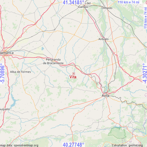
Vita GPS coordinates[2]
40° 48' 42.408" North, 5° 0' 20.988" West
| Map corner | latitude | longitude |
|---|---|---|
| Upper-left | 41.34181°, | -5.70896° |
| Center: | 40.81178°, | -5.00583° |
| Lower-right: | 40.27748°, | -4.30271° |
| Map W x H: | 118.3×118.3 km | = 73.5×73.5mi |
| max Lat: | 43.74134° ⇑56% North |
| Vita: | 40.81178° |
| min Lat: | ⇓44% South 27.64134° |
| min Long | Vita | max Long |
| -18.00367° | -5.00583° | 4.2899° |
| W 27.4%⇐ | ⇒72.6% E |
Elevation
Elevation of Vita is 997 m = 3271 ft, and this is 399 m = 1309 ft above average elevation for this country.
| Max E: |
1682 m = 5518 ft | 12% |
| Vita | 997 m 3271 ft | |
| Avg. | 598 m = 1962 ft | |
Min E: |
0 m = 0 ft | 88% |
See also: Spain elevation on elevation.city.
Geographical zone
Vita is located in North temperate zone (between Tropic of Cancer and the Arctic Circle). Distance of this Northern Tropic circle is 1931.9 km =1200.4 mi to South.| Distance of | km | miles | from Vita |
|---|---|---|---|
| North Pole | 5469.2 | 3398.4 | to North |
| Arctic Circle | 2863.3 | 1779.2 | to North |
| Tropic Cancer | 1931.9 | 1200.4 | to South |
| Equator | 4537.8 | 2819.7 | to South |


Nearby cities:
15 places around Vita: (largest is in red/bold)
• Albornos
10.9 km =6.8 mi,  74°
74°
• Blascomillán
6.9 km =4.3 mi,  260°
260°
• Brabos
6.7 km =4.2 mi,  123°
123°
• Collado de Contreras
10.5 km =6.5 mi,  36°
36°
• Crespos
7.2 km =4.5 mi,  23°
23°
• Herreros de Suso
2.9 km =1.8 mi,  251°
251°
• Muñogrande
7.1 km =4.4 mi,  80°
80°
• Narros del Castillo
6.9 km =4.3 mi,  318°
318°
• Rivilla de Barajas
10.1 km =6.3 mi,  8°
8°
• Salvadiós
10.6 km =6.6 mi,  314°
314°
• San García de Ingelmos
10.4 km =6.5 mi,  242°
242°
• San Pedro del Arroyo
11.4 km =7.1 mi,  95°
95°
• Santo Tomé de Zabarcos
8.5 km =5.3 mi,  108°
108°
• Sigeres
6.2 km =3.9 mi, 102°
• Viñegra de Moraña
8.3 km =5.2 mi,  58°
58°
Sources, notices
• [Note1] Compared only with cities in Spain existing in our database
• [Src1] Map data: © OpenStreetMap contributors (CC-BY-SA)
• [Src2] Other city data from geonames.org with taken over terms of usage.
• [Src3] Geographical zone / Annual Mean Temperature by Robert A. Rohde @ Wikipedia
