Villaviudas geodata
Villaviudas (Castille and León) is a seat of a third-order administrative division; located in Spain in Europe/Madrid (GMT+2) time zone. With population of 406 people, there are 4123 cities with bigger population in this country. Compared to other cities in Spain, 72.7% of cities are located further ↓South; 64.3% of cities are located further →East and 62.9% of cities have lower elevation than Villaviudas. Note1
Administrative division(s):
- Level 1: Castille and León
- Level 2: Provincia de Palencia
- Level 3: Villaviudas


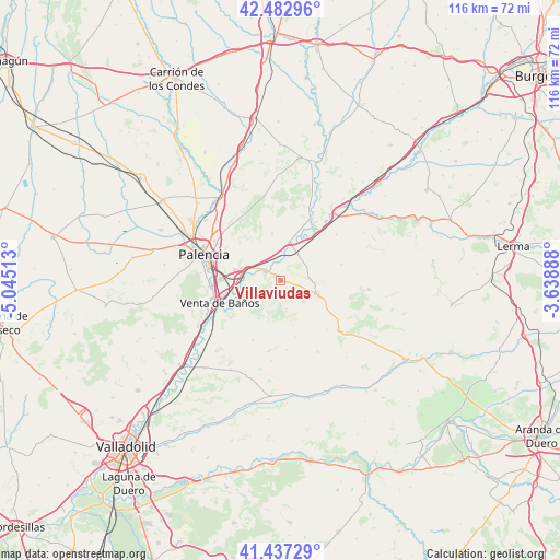
Villaviudas GPS coordinates[2]
41° 57' 44.172" North, 4° 20' 31.2" West
| Map corner | latitude | longitude |
|---|---|---|
| Upper-left | 42.48296°, | -5.04513° |
| Center: | 41.96227°, | -4.342° |
| Lower-right: | 41.43729°, | -3.63888° |
| Map W x H: | 116.3×116.3 km | = 72.3×72.3mi |
| max Lat: | 43.74134° ⇑27.3% North |
| Villaviudas: | 41.96227° |
| min Lat: | ⇓72.7% South 27.64134° |
| min Long | Villaviudas | max Long |
| -18.00367° | -4.342° | 4.2899° |
| W 35.7%⇐ | ⇒64.3% E |
Elevation
Elevation of Villaviudas is 764 m = 2507 ft, and this is 166 m = 545 ft above average elevation for this country.
| Max E: |
1682 m = 5518 ft | 37.1% |
| Villaviudas | 764 m 2507 ft | |
| Avg. | 598 m = 1962 ft | |
Min E: |
0 m = 0 ft | 62.9% |
See also: Spain elevation on elevation.city.
Geographical zone
Villaviudas is located in North temperate zone (between Tropic of Cancer and the Arctic Circle). Distance of this Northern Tropic circle is 2059.8 km =1279.9 mi to South.| Distance of | km | miles | from Villaviudas |
|---|---|---|---|
| North Pole | 5341.3 | 3318.9 | to North |
| Arctic Circle | 2735.4 | 1699.7 | to North |
| Tropic Cancer | 2059.8 | 1279.9 | to South |
| Equator | 4665.8 | 2899.2 | to South |


Nearby cities:
15 places around Villaviudas: (largest is in red/bold)
• Baltanás
8.4 km =5.2 mi,  109°
109°
• Castrillo de Onielo
12.1 km =7.5 mi,  163°
163°
• Cevico de la Torre
13.6 km =8.5 mi,  204°
204°
• Hontoria de Cerrato
10.1 km =6.3 mi,  235°
235°
• Hornillos de Cerrato
6.4 km =4 mi,  63°
63°
• Magaz
7.4 km =4.6 mi,  286°
286°
• Reinoso de Cerrato
3.8 km =2.4 mi, 294°
• Soto de Cerrato
7.3 km =4.5 mi,  262°
262°
• Tariego
13.2 km =8.2 mi, 240°
• Torquemada
8.3 km =5.2 mi,  13°
13°
• Valdeolmillos
10 km =6.2 mi,  331°
331°
• Valle de Cerrato
9.3 km =5.8 mi,  190°
190°
• Venta de Baños
13.1 km =8.1 mi,  249°
249°
• Villaconancio
14 km =8.7 mi,  135°
135°
• Villamediana
9.9 km =6.2 mi,  350°
350°
Sources, notices
• [Note1] Compared only with cities in Spain existing in our database
• [Src1] Map data: © OpenStreetMap contributors (CC-BY-SA)
• [Src2] Other city data from geonames.org with taken over terms of usage.
• [Src3] Geographical zone / Annual Mean Temperature by Robert A. Rohde @ Wikipedia
