Villardefrades geodata
Villardefrades (Castille and León) is a seat of a third-order administrative division; located in Spain in Europe/Madrid (GMT+2) time zone. With population of 212 people, there are 4965 cities with bigger population in this country. Compared to other cities in Spain, 66.6% of cities are located further ↓South; 75.8% of cities are located further →East and 57.2% of cities have lower elevation than Villardefrades. Note1
Administrative division(s):
- Level 1: Castille and León
- Level 2: Provincia de Valladolid
- Level 3: Villardefrades


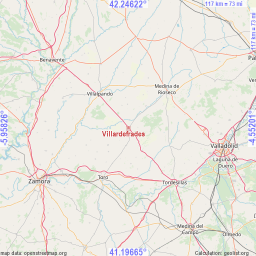
Villardefrades GPS coordinates[2]
41° 43' 24.888" North, 5° 15' 18.468" West
| Map corner | latitude | longitude |
|---|---|---|
| Upper-left | 42.24622°, | -5.95826° |
| Center: | 41.72358°, | -5.25513° |
| Lower-right: | 41.19665°, | -4.55201° |
| Map W x H: | 116.7×116.7 km | = 72.5×72.5mi |
| max Lat: | 43.74134° ⇑33.4% North |
| Villardefrades: | 41.72358° |
| min Lat: | ⇓66.6% South 27.64134° |
| min Long | Villardefrades | max Long |
| -18.00367° | -5.25513° | 4.2899° |
| W 24.2%⇐ | ⇒75.8% E |
Elevation
Elevation of Villardefrades is 725 m = 2379 ft, and this is 127 m = 417 ft above average elevation for this country.
| Max E: |
1682 m = 5518 ft | 42.8% |
| Villardefrades | 725 m 2379 ft | |
| Avg. | 598 m = 1962 ft | |
Min E: |
0 m = 0 ft | 57.2% |
See also: Spain elevation on elevation.city.
Geographical zone
Villardefrades is located in North temperate zone (between Tropic of Cancer and the Arctic Circle). Distance of this Northern Tropic circle is 2033.3 km =1263.4 mi to South.| Distance of | km | miles | from Villardefrades |
|---|---|---|---|
| North Pole | 5367.8 | 3335.4 | to North |
| Arctic Circle | 2761.9 | 1716.2 | to North |
| Tropic Cancer | 2033.3 | 1263.4 | to South |
| Equator | 4639.2 | 2882.7 | to South |


Nearby cities:
15 places around Villardefrades: (largest is in red/bold)
• Adalia
13.9 km =8.6 mi,  126°
126°
• Benafarces
11.8 km =7.3 mi,  195°
195°
• Castromembibre
7 km =4.3 mi,  215°
215°
• Mota del Marqués
12 km =7.5 mi,  147°
147°
• Pozuelo de la Orden
10.9 km =6.8 mi,  358°
358°
• San Cebrián de Mazote
10.1 km =6.3 mi,  118°
118°
• San Pedro de Latarce
6 km =3.7 mi,  282°
282°
• Tiedra
8 km =5 mi,  187°
187°
• Tordehumos
13 km =8.1 mi,  38°
38°
• Urueña
4.3 km =2.7 mi,  84°
84°
• Vezdemarbán
12 km =7.5 mi,  230°
230°
• Villagarcía de Campos
8.2 km =5.1 mi, 39°
• Villalbarba
13.8 km =8.6 mi,  165°
165°
• Villanueva de los Caballeros
4 km =2.5 mi,  8°
8°
• Villavellid
3.9 km =2.4 mi,  206°
206°
Sources, notices
• [Note1] Compared only with cities in Spain existing in our database
• [Src1] Map data: © OpenStreetMap contributors (CC-BY-SA)
• [Src2] Other city data from geonames.org with taken over terms of usage.
• [Src3] Geographical zone / Annual Mean Temperature by Robert A. Rohde @ Wikipedia
