Tiñosillos geodata
Tiñosillos (Castille and León) is a seat of a third-order administrative division; located in Spain in Europe/Madrid (GMT+2) time zone. With population of 785 people, there are 3243 cities with bigger population in this country. Compared to other cities in Spain, 53.2% of cities are located further ↑North; 68.9% of cities are located further →East and 77.3% of cities have lower elevation than Tiñosillos. Note1
Administrative division(s):
- Level 1: Castille and León
- Level 2: Provincia de Ávila
- Level 3: Tiñosillos


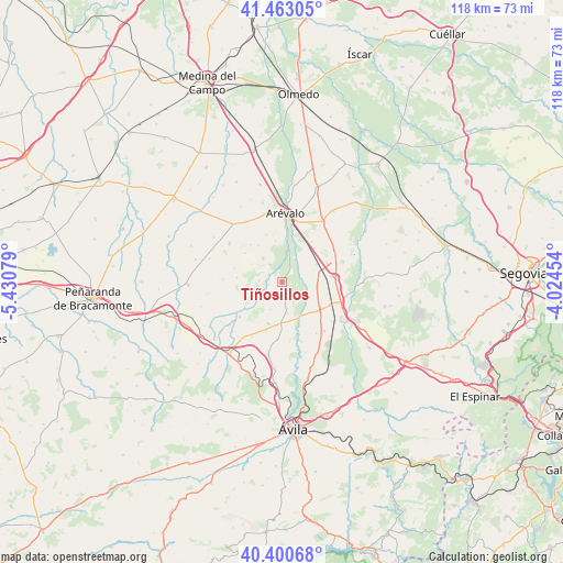
Tiñosillos GPS coordinates[2]
40° 56' 2.4" North, 4° 43' 39.612" West
| Map corner | latitude | longitude |
|---|---|---|
| Upper-left | 41.46305°, | -5.43079° |
| Center: | 40.934°, | -4.72767° |
| Lower-right: | 40.40068°, | -4.02454° |
| Map W x H: | 118.1×118.1 km | = 73.4×73.4mi |
| max Lat: | 43.74134° ⇑53.2% North |
| Tiñosillos: | 40.934° |
| min Lat: | ⇓46.8% South 27.64134° |
| min Long | Tiñosillos | max Long |
| -18.00367° | -4.72767° | 4.2899° |
| W 31.1%⇐ | ⇒68.9% E |
Elevation
Elevation of Tiñosillos is 873 m = 2864 ft, and this is 275 m = 902 ft above average elevation for this country.
| Max E: |
1682 m = 5518 ft | 22.7% |
| Tiñosillos | 873 m 2864 ft | |
| Avg. | 598 m = 1962 ft | |
Min E: |
0 m = 0 ft | 77.3% |
See also: Spain elevation on elevation.city.
Geographical zone
Tiñosillos is located in North temperate zone (between Tropic of Cancer and the Arctic Circle). Distance of this Northern Tropic circle is 1945.5 km =1208.9 mi to South.| Distance of | km | miles | from Tiñosillos |
|---|---|---|---|
| North Pole | 5455.6 | 3390 | to North |
| Arctic Circle | 2849.7 | 1770.7 | to North |
| Tropic Cancer | 1945.5 | 1208.9 | to South |
| Equator | 4551.4 | 2828.1 | to South |


Nearby cities:
15 places around Tiñosillos: (largest is in red/bold)
• Adanero
10.3 km =6.4 mi,  83°
83°
• Blascosancho
9.9 km =6.2 mi,  129°
129°
• Cabezas de Alambre
9.6 km =6 mi,  275°
275°
• Cabizuela
7.3 km =4.5 mi,  239°
239°
• Donjimeno
10.4 km =6.5 mi,  286°
286°
• Gotarrendura
12 km =7.5 mi,  185°
185°
• Gutierre-Muñoz
9.3 km =5.8 mi,  54°
54°
• Hernansancho
8.5 km =5.3 mi,  181°
181°
• Nava de Arévalo
6.3 km =3.9 mi,  320°
320°
• Orbita
9.8 km =6.1 mi,  42°
42°
• Pajares de Adaja
7.4 km =4.6 mi,  98°
98°
• Papatrigo
11.6 km =7.2 mi,  230°
230°
• San Pascual
6.3 km =3.9 mi,  202°
202°
• San Vicente de Arévalo
7.3 km =4.5 mi,  301°
301°
• Villanueva de Gómez
5.8 km =3.6 mi,  170°
170°
Sources, notices
• [Note1] Compared only with cities in Spain existing in our database
• [Src1] Map data: © OpenStreetMap contributors (CC-BY-SA)
• [Src2] Other city data from geonames.org with taken over terms of usage.
• [Src3] Geographical zone / Annual Mean Temperature by Robert A. Rohde @ Wikipedia
