Galinduste geodata
Galinduste (Castille and León) is a seat of a third-order administrative division; located in Spain in Europe/Madrid (GMT+2) time zone. With population of 531 people, there are 3788 cities with bigger population in this country. Compared to other cities in Spain, 58.6% of cities are located further ↑North; 79.2% of cities are located further →East and 85.2% of cities have lower elevation than Galinduste. Note1
Administrative division(s):
- Level 1: Castille and León
- Level 2: Provincia de Salamanca
- Level 3: Galinduste


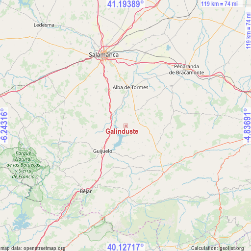
Galinduste GPS coordinates[2]
40° 39' 45.576" North, 5° 32' 24.108" West
| Map corner | latitude | longitude |
|---|---|---|
| Upper-left | 41.19389°, | -6.24316° |
| Center: | 40.66266°, | -5.54003° |
| Lower-right: | 40.12717°, | -4.83691° |
| Map W x H: | 118.6×118.6 km | = 73.7×73.7mi |
| max Lat: | 43.74134° ⇑58.6% North |
| Galinduste: | 40.66266° |
| min Lat: | ⇓41.4% South 27.64134° |
| min Long | Galinduste | max Long |
| -18.00367° | -5.54003° | 4.2899° |
| W 20.8%⇐ | ⇒79.2% E |
Elevation
Elevation of Galinduste is 953 m = 3127 ft, and this is 355 m = 1165 ft above average elevation for this country.
| Max E: |
1682 m = 5518 ft | 14.8% |
| Galinduste | 953 m 3127 ft | |
| Avg. | 598 m = 1962 ft | |
Min E: |
0 m = 0 ft | 85.2% |
See also: Spain elevation on elevation.city.
Geographical zone
Galinduste is located in North temperate zone (between Tropic of Cancer and the Arctic Circle). Distance of this Northern Tropic circle is 1915.3 km =1190.1 mi to South.| Distance of | km | miles | from Galinduste |
|---|---|---|---|
| North Pole | 5485.8 | 3408.7 | to North |
| Arctic Circle | 2879.9 | 1789.5 | to North |
| Tropic Cancer | 1915.3 | 1190.1 | to South |
| Equator | 4521.3 | 2809.4 | to South |


Nearby cities:
15 places around Galinduste: (largest is in red/bold)
• Aldeavieja de Tormes
11 km =6.8 mi,  216°
216°
• Anaya de Alba
8.3 km =5.2 mi,  28°
28°
• Armenteros
10.9 km =6.8 mi,  134°
134°
• Beleña
12.2 km =7.6 mi,  323°
323°
• Berrocal de Salvatierra
13.1 km =8.1 mi,  255°
255°
• Buenavista
13.1 km =8.1 mi,  332°
332°
• Ejeme
11.6 km =7.2 mi,  0°
0°
• Encinas de Arriba
12.1 km =7.5 mi,  353°
353°
• Galisancho
9.1 km =5.7 mi, 352°
• Larrodrigo
11.3 km =7 mi,  42°
42°
• Montejo
7.8 km =4.8 mi,  244°
244°
• Narrillos del Álamo
12.4 km =7.7 mi,  149°
149°
• Pelayos
3.3 km =2.1 mi, 244°
• Pizarral
10.9 km =6.8 mi, 240°
• Salvatierra de Tormes
9.4 km =5.8 mi,  211°
211°
Sources, notices
• [Note1] Compared only with cities in Spain existing in our database
• [Src1] Map data: © OpenStreetMap contributors (CC-BY-SA)
• [Src2] Other city data from geonames.org with taken over terms of usage.
• [Src3] Geographical zone / Annual Mean Temperature by Robert A. Rohde @ Wikipedia
