Creixell geodata
Creixell (Catalonia) is a seat of a third-order administrative division; located in Spain in Europe/Madrid (GMT+2) time zone. With population of 2,510 people, there are 1901 cities with bigger population in this country. Compared to other cities in Spain, 52.4% of cities are located further ↓South; 91.7% of cities are located further ←West and 93.4% of cities have higher elevation than Creixell. Note1


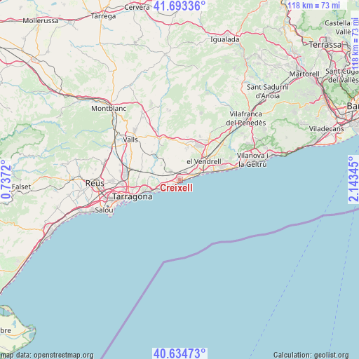
Creixell GPS coordinates[2]
41° 9' 58.248" North, 1° 26' 25.152" East
| Map corner | latitude | longitude |
|---|---|---|
| Upper-left | 41.69336°, | 0.7372° |
| Center: | 41.16618°, | 1.44032° |
| Lower-right: | 40.63473°, | 2.14345° |
| Map W x H: | 117.7×117.7 km | = 73.1×73.1mi |
| max Lat: | 43.74134° ⇑47.6% North |
| Creixell: | 41.16618° |
| min Lat: | ⇓52.4% South 27.64134° |
| min Long | Creixell | max Long |
| -18.00367° | 1.44032° | 4.2899° |
| W 91.7%⇐ | ⇒8.3% E |
Elevation
Elevation of Creixell is 35 m = 115 ft, and this is 563 m = 1847 ft below average elevation for this country.
| Max E: |
1682 m = 5518 ft | 93.4% |
| Avg. | 598 m = 1962 ft | |
| Creixell | 35 m = 115 ft | |
Min E: |
0 m = 0 ft | 6.6% |
See also: Spain elevation on elevation.city.
Geographical zone
Creixell is located in North temperate zone (between Tropic of Cancer and the Arctic Circle). Distance of this Northern Tropic circle is 1971.3 km =1224.9 mi to South.| Distance of | km | miles | from Creixell |
|---|---|---|---|
| North Pole | 5429.8 | 3373.9 | to North |
| Arctic Circle | 2823.9 | 1754.7 | to North |
| Tropic Cancer | 1971.3 | 1224.9 | to South |
| Equator | 4577.3 | 2844.2 | to South |


Nearby cities:
15 places around Creixell: (largest is in red/bold)
• Albinyana
10 km =6.2 mi,  21°
21°
• Altafulla
6.2 km =3.9 mi,  245°
245°
• Bonastre
6 km =3.7 mi,  359°
359°
• Calafell
11.3 km =7 mi,  70°
70°
• Coma-ruga
7.3 km =4.5 mi,  77°
77°
• El Vendrell
9.6 km =6 mi,  54°
54°
• Montferri
12.7 km =7.9 mi,  330°
330°
• Renau
12.6 km =7.8 mi,  300°
300°
• Roda de Barà
2.7 km =1.7 mi,  34°
34°
• Salomó
8.9 km =5.5 mi,  321°
321°
• Santa Oliva
13.4 km =8.3 mi,  43°
43°
• Torredembarra
4.2 km =2.6 mi,  236°
236°
• Vilabella
12.9 km =8 mi,  314°
314°
• el Catllar
10.4 km =6.5 mi,  270°
270°
• la Bisbal del Penedès
13.5 km =8.4 mi, 15°
Sources, notices
• [Note1] Compared only with cities in Spain existing in our database
• [Src1] Map data: © OpenStreetMap contributors (CC-BY-SA)
• [Src2] Other city data from geonames.org with taken over terms of usage.
• [Src3] Geographical zone / Annual Mean Temperature by Robert A. Rohde @ Wikipedia
