Carazo geodata
Carazo (Castille and León) is a seat of a third-order administrative division; located in Spain in Europe/Madrid (GMT+2) time zone. With population of 45 people, there are 6517 cities with bigger population in this country. Compared to other cities in Spain, 72.8% of cities are located further ↓South; 50.2% of cities are located further →East and 94.7% of cities have lower elevation than Carazo. Note1


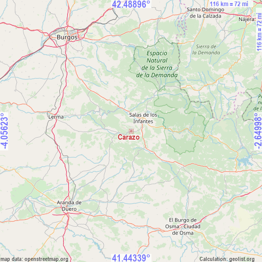
Carazo GPS coordinates[2]
41° 58' 5.952" North, 3° 21' 11.16" West
| Map corner | latitude | longitude |
|---|---|---|
| Upper-left | 42.48896°, | -4.05623° |
| Center: | 41.96832°, | -3.3531° |
| Lower-right: | 41.44339°, | -2.64998° |
| Map W x H: | 116.3×116.3 km | = 72.3×72.3mi |
| max Lat: | 43.74134° ⇑27.2% North |
| Carazo: | 41.96832° |
| min Lat: | ⇓72.8% South 27.64134° |
| min Long | Carazo | max Long |
| -18.00367° | -3.3531° | 4.2899° |
| W 49.8%⇐ | ⇒50.2% E |
Elevation
Elevation of Carazo is 1129 m = 3704 ft, and this is 531 m = 1742 ft above average elevation for this country.
| Max E: |
1682 m = 5518 ft | 5.3% |
| Carazo | 1129 m 3704 ft | |
| Avg. | 598 m = 1962 ft | |
Min E: |
0 m = 0 ft | 94.7% |
See also: Spain elevation on elevation.city.
Geographical zone
Carazo is located in North temperate zone (between Tropic of Cancer and the Arctic Circle). Distance of this Northern Tropic circle is 2060.5 km =1280.3 mi to South.| Distance of | km | miles | from Carazo |
|---|---|---|---|
| North Pole | 5340.6 | 3318.5 | to North |
| Arctic Circle | 2734.7 | 1699.3 | to North |
| Tropic Cancer | 2060.5 | 1280.3 | to South |
| Equator | 4666.4 | 2899.6 | to South |


Nearby cities:
15 places around Carazo: (largest is in red/bold)
• Arauzo de Miel
12.5 km =7.8 mi,  193°
193°
• Barbadillo del Mercado
7.8 km =4.8 mi,  357°
357°
• Cabezón de la Sierra
10 km =6.2 mi,  112°
112°
• Cascajares de la Sierra
11.1 km =6.9 mi,  339°
339°
• Castrillo de la Reina
9.9 km =6.2 mi,  77°
77°
• Contreras
7.5 km =4.7 mi,  320°
320°
• Espinosa de Cervera
12.4 km =7.7 mi,  230°
230°
• Hacinas
5.8 km =3.6 mi,  71°
71°
• Mamolar
4.6 km =2.9 mi, 189°
• Pinilla de los Barruecos
6.9 km =4.3 mi,  143°
143°
• Pinilla de los Moros
11.3 km =7 mi,  10°
10°
• Salas de los Infantes
8.2 km =5.1 mi,  42°
42°
• Santibáñez del Val
10.6 km =6.6 mi,  273°
273°
• Santo Domingo de Silos
5.3 km =3.3 mi,  264°
264°
• Villanueva de Carazo
2.9 km =1.8 mi,  56°
56°
Sources, notices
• [Note1] Compared only with cities in Spain existing in our database
• [Src1] Map data: © OpenStreetMap contributors (CC-BY-SA)
• [Src2] Other city data from geonames.org with taken over terms of usage.
• [Src3] Geographical zone / Annual Mean Temperature by Robert A. Rohde @ Wikipedia
