Nadi geodata
Nadi (Western) is a populated place; located in Fiji in Pacific/Fiji (GMT+12) time zone. With population of 42,284 people, there are 2 cities with bigger population in this country. Compared to other cities in Fiji, 57.1% of cities are located further ↑North; 71.4% of cities are located further →East and 71.4% of cities have higher elevation than Nadi. Note1


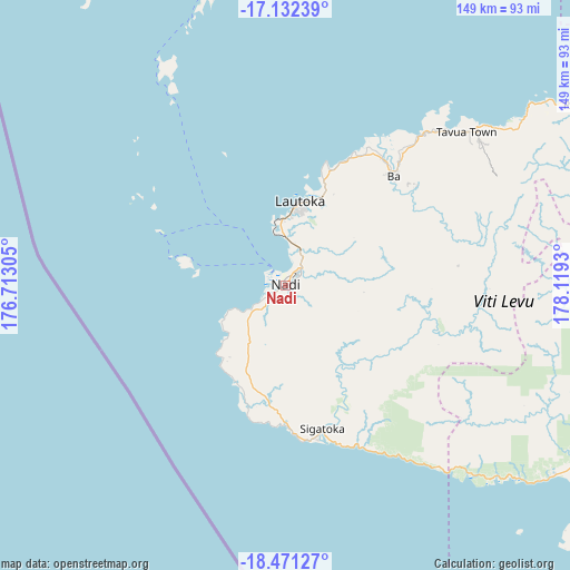
Nadi GPS coordinates[2]
17° 48' 11.124" South, 177° 24' 58.212" East
| Map corner | latitude | longitude |
|---|---|---|
| Upper-left | -17.13239°, | 176.71305° |
| Center: | -17.80309°, | 177.41617° |
| Lower-right: | -18.47127°, | 178.1193° |
| Map W x H: | 148.9×148.9 km | = 92.5×92.5mi |
| max Lat: | -12.5° ⇑57.1% North |
| Nadi: | -17.80309° |
| min Lat: | ⇓42.9% South -18.23652° |
| min Long | Nadi | max Long |
| -178.81232° | 177.41617° | 179.36451° |
| W 28.6%⇐ | ⇒71.4% E |
Elevation
Elevation of Nadi is 9 m = 30 ft, and this is 20.9 m = 69 ft below average elevation for this country.
| Max E: |
57 m = 187 ft | 71.4% |
| Avg. | 29.9 m = 98 ft | |
| Nadi | 9 m = 30 ft | |
Min E: |
5 m = 16 ft | 28.6% |
See also: Nadi elevation on elevation.city.
Geographical zone
Nadi is located in South Torrid zone (between Equator and Tropic of Capricorn). Distance of this Southern Tropic circle is 626.4 km =389.2 mi to South.| Distance of | km | miles | from Nadi |
|---|---|---|---|
| Equator | 1979.5 | 1230 | to North |
| Tropic Capricorn | 626.4 | 389.2 | to South |
| Antarctic Circle | 5421.7 | 3368.9 | to South |
| South Pole | 8027.5 | 4988.1 | to South |


Nearby cities:
5 places around Nadi: (largest is in red/bold)
• Ba
40.5 km =25.2 mi,  42°
42°
• Labasa
257 km =159.7 mi,  53°
53°
• Lautoka
21 km =13 mi,  9°
9°
• Levuka
203.2 km =126.3 mi,  98°
98°
• Suva
114.8 km =71.3 mi,  109°
109°
Sources, notices
• [Note1] Compared only with cities in Fiji existing in our database
• [Src1] Map data: © OpenStreetMap contributors (CC-BY-SA)
• [Src2] Other city data from geonames.org with taken over terms of usage.
• [Src3] Geographical zone / Annual Mean Temperature by Robert A. Rohde @ Wikipedia
