Virsac geodata
Virsac (Nouvelle-Aquitaine) is a populated place; located in France in Europe/Paris (GMT+2) time zone. With population of 975 people, there are 9023 cities with bigger population in this country. Compared to other cities in France, 79.3% of cities are located further ↑North; 82.8% of cities are located further →East and 86.2% of cities have higher elevation than Virsac. Note1
Administrative division(s):
- Level 1: Nouvelle-Aquitaine
- Level 2: Gironde
- Level 3: Arrondissement de Blaye
- Level 4: Virsac


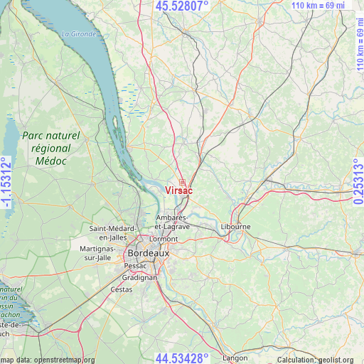
Virsac GPS coordinates[2]
45° 1' 59.988" North, 0° 27' 0" West
| Map corner | latitude | longitude |
|---|---|---|
| Upper-left | 45.52807°, | -1.15312° |
| Center: | 45.03333°, | -0.45° |
| Lower-right: | 44.53428°, | 0.25313° |
| Map W x H: | 110.5×110.5 km | = 68.7×68.7mi |
| max Lat: | 51.07786° ⇑79.3% North |
| Virsac: | 45.03333° |
| min Lat: | ⇓20.7% South 41.3874° |
| min Long | Virsac | max Long |
| -5.08615° | -0.45° | 9.52242° |
| W 17.2%⇐ | ⇒82.8% E |
Elevation
Elevation of Virsac is 39 m = 128 ft, and this is 154.7 m = 508 ft below average elevation for this country.
| Max E: |
2333 m = 7654 ft | 86.2% |
| Avg. | 193.7 m = 635 ft | |
| Virsac | 39 m = 128 ft | |
Min E: |
-1 m = -3 ft | 13.8% |
See also: France elevation on elevation.city.
Geographical zone
Virsac is located in North temperate zone (between Tropic of Cancer and the Arctic Circle). Distance of this North polar circle is 2393.9 km =1487.5 mi to North.| Distance of | km | miles | from Virsac |
|---|---|---|---|
| North Pole | 4999.8 | 3106.7 | to North |
| Arctic Circle | 2393.9 | 1487.5 | to North |
| Tropic Cancer | 2401.3 | 1492.1 | to South |
| Equator | 5007.2 | 3111.3 | to South |


Nearby cities:
15 places around Virsac: (largest is in red/bold)
• Ambès
6.9 km =4.3 mi,  249°
249°
• Aubie-et-Espessas
4 km =2.5 mi,  113°
113°
• Cubzac-les-Ponts
6.9 km =4.3 mi,  179°
179°
• Cézac
6.8 km =4.2 mi,  20°
20°
• Gauriaguet
4.6 km =2.9 mi,  82°
82°
• La Lande-de-Fronsac
8 km =5 mi,  137°
137°
• Lansac
7.9 km =4.9 mi,  293°
293°
• Marcamps
3.5 km =2.2 mi,  283°
283°
• Marsas
6.6 km =4.1 mi,  54°
54°
• Peujard
0.8 km =0.5 mi,  65°
65°
• Pugnac
6.5 km =4 mi,  326°
326°
• Saint-Genès-de-Fronsac
7.2 km =4.5 mi,  97°
97°
• Saint-Gervais
2 km =1.2 mi,  185°
185°
• Salignac
5.9 km =3.7 mi, 109°
• Tauriac
4.3 km =2.7 mi, 293°
Sources, notices
• [Note1] Compared only with cities in France existing in our database
• [Src1] Map data: © OpenStreetMap contributors (CC-BY-SA)
• [Src2] Other city data from geonames.org with taken over terms of usage.
• [Src3] Geographical zone / Annual Mean Temperature by Robert A. Rohde @ Wikipedia
