Vire geodata
Vire (Normandy) is a seat of a third-order administrative division; located in France in Europe/Paris (GMT+2) time zone. With population of 14,603 people, there are 655 cities with bigger population in this country. Compared to other cities in France, 76.3% of cities are located further ↓South; 87.2% of cities are located further →East and 66.2% of cities have lower elevation than Vire. Note1
Administrative division(s):
- Level 1: Normandy
- Level 2: Calvados
- Level 3: Arrondissement de Vire
- Level 4: Vire Normandie


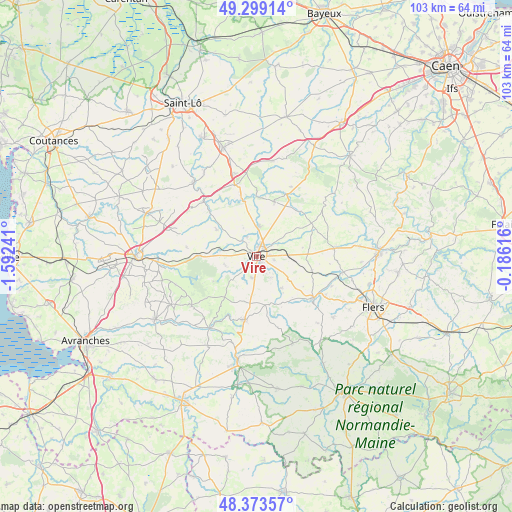
Vire GPS coordinates[2]
48° 50' 18.564" North, 0° 53' 21.444" West
| Map corner | latitude | longitude |
|---|---|---|
| Upper-left | 49.29914°, | -1.59241° |
| Center: | 48.83849°, | -0.88929° |
| Lower-right: | 48.37357°, | -0.18616° |
| Map W x H: | 102.9×102.9 km | = 63.9×63.9mi |
| max Lat: | 51.07786° ⇑23.7% North |
| Vire: | 48.83849° |
| min Lat: | ⇓76.3% South 41.3874° |
| min Long | Vire | max Long |
| -5.08615° | -0.88929° | 9.52242° |
| W 12.8%⇐ | ⇒87.2% E |
Elevation
Elevation of Vire is 200 m = 656 ft, and this is 6.3 m = 21 ft above average elevation for this country.
| Max E: |
2333 m = 7654 ft | 33.8% |
| Vire | 200 m 656 ft | |
| Avg. | 193.7 m = 635 ft | |
Min E: |
-1 m = -3 ft | 66.2% |
See also: France elevation on elevation.city.
Geographical zone
Vire is located in North temperate zone (between Tropic of Cancer and the Arctic Circle). Distance of this North polar circle is 1970.8 km =1224.6 mi to North.| Distance of | km | miles | from Vire |
|---|---|---|---|
| North Pole | 4576.7 | 2843.8 | to North |
| Arctic Circle | 1970.8 | 1224.6 | to North |
| Tropic Cancer | 2824.4 | 1755 | to South |
| Equator | 5430.3 | 3374.2 | to South |


Nearby cities:
15 places around Vire: (largest is in red/bold)
• Bernières-le-Patry
11.5 km =7.1 mi,  103°
103°
• Campeaux
12.8 km =8 mi,  346°
346°
• Landelles-et-Coupigny
9.7 km =6 mi,  304°
304°
• Le Bény-Bocage
11.5 km =7.1 mi,  18°
18°
• Mesnil-Clinchamps
7.5 km =4.7 mi,  282°
282°
• Montchamp
12.9 km =8 mi,  44°
44°
• Roullours
3.7 km =2.3 mi, 99°
• Saint-Manvieu-Bocage
6.6 km =4.1 mi,  257°
257°
• Saint-Sever-Calvados
11.6 km =7.2 mi,  271°
271°
• Sainte-Marie-Laumont
8.9 km =5.5 mi,  0°
0°
• Sourdeval
13.1 km =8.1 mi,  190°
190°
• Truttemer-le-Grand
8.2 km =5.1 mi,  140°
140°
• Vaudry
2.7 km =1.7 mi,  83°
83°
• Vengeons
9.6 km =6 mi, 192°
• Viessoix
6.6 km =4.1 mi,  89°
89°
Sources, notices
• [Note1] Compared only with cities in France existing in our database
• [Src1] Map data: © OpenStreetMap contributors (CC-BY-SA)
• [Src2] Other city data from geonames.org with taken over terms of usage.
• [Src3] Geographical zone / Annual Mean Temperature by Robert A. Rohde @ Wikipedia
