Sormiou geodata
Sormiou (Provence-Alpes-Côte d'Azur) is a section of populated place; located in France in Europe/Paris (GMT+2) time zone. With population of 6,809 people, there are 1453 cities with bigger population in this country. Compared to other cities in France, 97% of cities are located further ↑North; 82.2% of cities are located further ←West and 84.5% of cities have higher elevation than Sormiou. Note1
Administrative division(s):
- Level 1: Provence-Alpes-Côte d'Azur
- Level 2: Département des Bouches-du-Rhône
- Level 3: Arrondissement de Marseille
- Level 4: Marseille


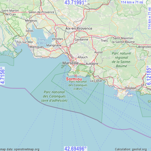
Sormiou GPS coordinates[2]
43° 12' 34.524" North, 5° 25' 7.392" East
| Map corner | latitude | longitude |
|---|---|---|
| Upper-left | 43.71991°, | 4.7156° |
| Center: | 43.20959°, | 5.41872° |
| Lower-right: | 42.69496°, | 6.12185° |
| Map W x H: | 114×114 km | = 70.8×70.8mi |
| max Lat: | 51.07786° ⇑97% North |
| Sormiou: | 43.20959° |
| min Lat: | ⇓3% South 41.3874° |
| min Long | Sormiou | max Long |
| -5.08615° | 5.41872° | 9.52242° |
| W 82.2%⇐ | ⇒17.8% E |
Elevation
Elevation of Sormiou is 43 m = 141 ft, and this is 150.7 m = 494 ft below average elevation for this country.
| Max E: |
2333 m = 7654 ft | 84.5% |
| Avg. | 193.7 m = 635 ft | |
| Sormiou | 43 m = 141 ft | |
Min E: |
-1 m = -3 ft | 15.5% |
See also: France elevation on elevation.city.
Geographical zone
Sormiou is located in North temperate zone (between Tropic of Cancer and the Arctic Circle). Distance of this Northern Tropic circle is 2198.5 km =1366.1 mi to South.| Distance of | km | miles | from Sormiou |
|---|---|---|---|
| North Pole | 5202.6 | 3232.7 | to North |
| Arctic Circle | 2596.7 | 1613.5 | to North |
| Tropic Cancer | 2198.5 | 1366.1 | to South |
| Equator | 4804.5 | 2985.4 | to South |


Nearby cities:
15 places around Sormiou: (largest is in red/bold)
• Bonneveine
5.3 km =3.3 mi,  327°
327°
• La Panouse
5.2 km =3.2 mi,  9°
9°
• La Pointe Rouge
4.7 km =2.9 mi,  313°
313°
• Le Cabot
5.5 km =3.4 mi,  358°
358°
• Le Redon
4.1 km =2.5 mi, 11°
• Les Baumettes
1.9 km =1.2 mi,  354°
354°
• Marseille 09
5.1 km =3.2 mi, 348°
• Mazargues
4.4 km =2.7 mi,  337°
337°
• Montredon
5.4 km =3.4 mi, 308°
• Saint-Giniez
7.2 km =4.5 mi, 338°
• Saint-Tronc
6.8 km =4.2 mi,  2°
2°
• Sainte-Anne
5.7 km =3.5 mi, 339°
• Sainte-Marguerite
6 km =3.7 mi, 346°
• Vaufrège
4.8 km =3 mi,  23°
23°
• Vieille Chapelle
5.4 km =3.4 mi, 325°
Sources, notices
• [Note1] Compared only with cities in France existing in our database
• [Src1] Map data: © OpenStreetMap contributors (CC-BY-SA)
• [Src2] Other city data from geonames.org with taken over terms of usage.
• [Src3] Geographical zone / Annual Mean Temperature by Robert A. Rohde @ Wikipedia
