Saint-Laurent geodata
Saint-Laurent (Grand Est) is a populated place; located in France in Europe/Paris (GMT+2) time zone. With population of 1,179 people, there are 7653 cities with bigger population in this country. Compared to other cities in France, 92% of cities are located further ↓South; 74.7% of cities are located further ←West and 75.4% of cities have lower elevation than Saint-Laurent. Note1
Administrative division(s):
- Level 1: Grand Est
- Level 2: Ardennes
- Level 3: Arrondissement de Charleville-Mézières
- Level 4: Saint-Laurent


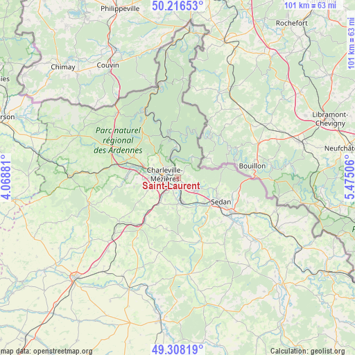
Saint-Laurent GPS coordinates[2]
49° 45' 52.164" North, 4° 46' 18.948" East
| Map corner | latitude | longitude |
|---|---|---|
| Upper-left | 50.21653°, | 4.06881° |
| Center: | 49.76449°, | 4.77193° |
| Lower-right: | 49.30819°, | 5.47506° |
| Map W x H: | 101×101 km | = 62.8×62.8mi |
| max Lat: | 51.07786° ⇑8% North |
| Saint-Laurent: | 49.76449° |
| min Lat: | ⇓92% South 41.3874° |
| min Long | Saint-Laurent | max Long |
| -5.08615° | 4.77193° | 9.52242° |
| W 74.7%⇐ | ⇒25.3% E |
Elevation
Elevation of Saint-Laurent is 252 m = 827 ft, and this is 58.3 m = 191 ft above average elevation for this country.
| Max E: |
2333 m = 7654 ft | 24.6% |
| Saint-Laurent | 252 m 827 ft | |
| Avg. | 193.7 m = 635 ft | |
Min E: |
-1 m = -3 ft | 75.4% |
See also: France elevation on elevation.city.
Geographical zone
Saint-Laurent is located in North temperate zone (between Tropic of Cancer and the Arctic Circle). Distance of this North polar circle is 1867.9 km =1160.7 mi to North.| Distance of | km | miles | from Saint-Laurent |
|---|---|---|---|
| North Pole | 4473.8 | 2779.9 | to North |
| Arctic Circle | 1867.9 | 1160.7 | to North |
| Tropic Cancer | 2927.4 | 1819 | to South |
| Equator | 5533.3 | 3438.2 | to South |


Nearby cities:
15 places around Saint-Laurent: (largest is in red/bold)
• Aiglemont
1.8 km =1.1 mi,  343°
343°
• Chalandry-Elaire
5.5 km =3.4 mi,  196°
196°
• Charleville-Mézières
3.4 km =2.1 mi,  277°
277°
• La Francheville
5.8 km =3.6 mi,  227°
227°
• La Grandville
2.4 km =1.5 mi,  43°
43°
• Les Ayvelles
4.8 km =3 mi,  192°
192°
• Lumes
3.5 km =2.2 mi,  162°
162°
• Montcy-Notre-Dame
2.4 km =1.5 mi,  299°
299°
• Neufmanil
5.5 km =3.4 mi,  19°
19°
• Nouzonville
5.7 km =3.5 mi, 342°
• Prix-lès-Mézières
5.9 km =3.7 mi,  260°
260°
• Villers-Semeuse
3.1 km =1.9 mi,  215°
215°
• Vivier-au-Court
5.4 km =3.4 mi,  130°
130°
• Vrigne-aux-Bois
6.7 km =4.2 mi,  116°
116°
• Warcq
6.6 km =4.1 mi, 280°
Sources, notices
• [Note1] Compared only with cities in France existing in our database
• [Src1] Map data: © OpenStreetMap contributors (CC-BY-SA)
• [Src2] Other city data from geonames.org with taken over terms of usage.
• [Src3] Geographical zone / Annual Mean Temperature by Robert A. Rohde @ Wikipedia
