Saint-Jean-le-Vieux geodata
Saint-Jean-le-Vieux (Auvergne-Rhône-Alpes) is a populated place; located in France in Europe/Paris (GMT+2) time zone. With population of 1,518 people, there are 6126 cities with bigger population in this country. Compared to other cities in France, 65.9% of cities are located further ↑North; 81.7% of cities are located further ←West and 77.2% of cities have lower elevation than Saint-Jean-le-Vieux. Note1
Administrative division(s):
- Level 1: Auvergne-Rhône-Alpes
- Level 2: Département de l'Ain
- Level 3: Arrondissement de Nantua
- Level 4: Saint-Jean-le-Vieux


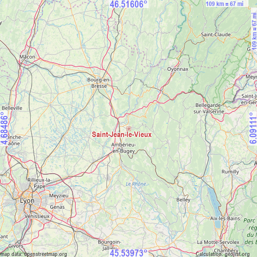
Saint-Jean-le-Vieux GPS coordinates[2]
46° 1' 48.18" North, 5° 23' 16.728" East
| Map corner | latitude | longitude |
|---|---|---|
| Upper-left | 46.51606°, | 4.68486° |
| Center: | 46.03005°, | 5.38798° |
| Lower-right: | 45.53973°, | 6.09111° |
| Map W x H: | 108.6×108.6 km | = 67.5×67.5mi |
| max Lat: | 51.07786° ⇑65.9% North |
| Saint-Jean-le-Vieux: | 46.03005° |
| min Lat: | ⇓34.1% South 41.3874° |
| min Long | Saint-Jean-le-V | max Long |
| -5.08615° | 5.38798° | 9.52242° |
| W 81.7%⇐ | ⇒18.3% E |
Elevation
Elevation of Saint-Jean-le-Vieux is 265 m = 869 ft, and this is 71.3 m = 234 ft above average elevation for this country.
| Max E: |
2333 m = 7654 ft | 22.8% |
| Saint-Jean-le-Vieux | 265 m 869 ft | |
| Avg. | 193.7 m = 635 ft | |
Min E: |
-1 m = -3 ft | 77.2% |
See also: France elevation on elevation.city.
Geographical zone
Saint-Jean-le-Vieux is located in North temperate zone (between Tropic of Cancer and the Arctic Circle). Distance of this North polar circle is 2283.1 km =1418.7 mi to North.| Distance of | km | miles | from Saint-Jean-le-Vieux |
|---|---|---|---|
| North Pole | 4889 | 3037.9 | to North |
| Arctic Circle | 2283.1 | 1418.7 | to North |
| Tropic Cancer | 2512.1 | 1560.9 | to South |
| Equator | 5118.1 | 3180.2 | to South |


Nearby cities:
15 places around Saint-Jean-le-Vieux: (largest is in red/bold)
• Ambronay
3.4 km =2.1 mi,  214°
214°
• Ambérieu-en-Bugey
8.4 km =5.2 mi,  199°
199°
• Bettant
9.8 km =6.1 mi,  193°
193°
• Cerdon
8.2 km =5.1 mi,  46°
46°
• Château-Gaillard
9.1 km =5.7 mi,  225°
225°
• Douvres
4.7 km =2.9 mi, 194°
• Druillat
6.4 km =4 mi,  300°
300°
• Jujurieux
2 km =1.2 mi, 51°
• Neuville-sur-Ain
4.7 km =2.9 mi,  347°
347°
• Poncin
6.4 km =4 mi,  16°
16°
• Pont-d’Ain
4.7 km =2.9 mi,  307°
307°
• Priay
8.4 km =5.2 mi,  248°
248°
• Saint-Denis-en-Bugey
10.1 km =6.3 mi, 207°
• Saint-Martin-du-Mont
9.3 km =5.8 mi,  324°
324°
• Saint-Rambert-en-Bugey
9.9 km =6.2 mi,  157°
157°
Sources, notices
• [Note1] Compared only with cities in France existing in our database
• [Src1] Map data: © OpenStreetMap contributors (CC-BY-SA)
• [Src2] Other city data from geonames.org with taken over terms of usage.
• [Src3] Geographical zone / Annual Mean Temperature by Robert A. Rohde @ Wikipedia
