Montry geodata
Montry (Île-de-France) is a populated place; located in France in Europe/Paris (GMT+2) time zone. With population of 3,434 people, there are 2830 cities with bigger population in this country. Compared to other cities in France, 77.3% of cities are located further ↓South; 55.4% of cities are located further ←West and 78.2% of cities have higher elevation than Montry. Note1
Administrative division(s):
- Level 1: Île-de-France
- Level 2: Seine-et-Marne
- Level 3: Arrondissement de Meaux
- Level 4: Montry


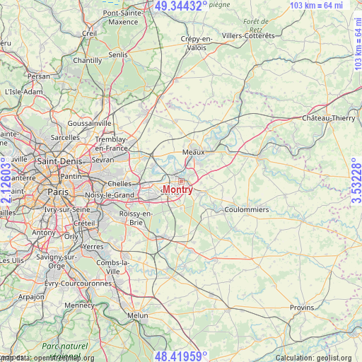
Montry GPS coordinates[2]
48° 53' 2.724" North, 2° 49' 44.94" East
| Map corner | latitude | longitude |
|---|---|---|
| Upper-left | 49.34432°, | 2.12603° |
| Center: | 48.88409°, | 2.82915° |
| Lower-right: | 48.41959°, | 3.53228° |
| Map W x H: | 102.8×102.8 km | = 63.9×63.9mi |
| max Lat: | 51.07786° ⇑22.7% North |
| Montry: | 48.88409° |
| min Lat: | ⇓77.3% South 41.3874° |
| min Long | Montry | max Long |
| -5.08615° | 2.82915° | 9.52242° |
| W 55.4%⇐ | ⇒44.6% E |
Elevation
Elevation of Montry is 59 m = 194 ft, and this is 134.7 m = 442 ft below average elevation for this country.
| Max E: |
2333 m = 7654 ft | 78.2% |
| Avg. | 193.7 m = 635 ft | |
| Montry | 59 m = 194 ft | |
Min E: |
-1 m = -3 ft | 21.8% |
See also: France elevation on elevation.city.
Geographical zone
Montry is located in North temperate zone (between Tropic of Cancer and the Arctic Circle). Distance of this North polar circle is 1965.8 km =1221.5 mi to North.| Distance of | km | miles | from Montry |
|---|---|---|---|
| North Pole | 4571.7 | 2840.7 | to North |
| Arctic Circle | 1965.8 | 1221.5 | to North |
| Tropic Cancer | 2829.5 | 1758.2 | to South |
| Equator | 5435.4 | 3377.4 | to South |


Nearby cities:
15 places around Montry: (largest is in red/bold)
• Bailly-Romainvilliers
4.1 km =2.5 mi,  185°
185°
• Chalifert
4.1 km =2.5 mi,  279°
279°
• Chessy
4.6 km =2.9 mi,  268°
268°
• Condé-Sainte-Libiaire
1.6 km =1 mi,  26°
26°
• Couilly-Pont-aux-Dames
2 km =1.2 mi,  87°
87°
• Coupvray
2.6 km =1.6 mi,  292°
292°
• Coutevroult
3 km =1.9 mi,  144°
144°
• Esbly
2.6 km =1.6 mi,  332°
332°
• Isles-lès-Villenoy
3.2 km =2 mi,  357°
357°
• Lesches
4.4 km =2.7 mi,  309°
309°
• Magny-le-Hongre
2.5 km =1.6 mi,  203°
203°
• Mareuil-lès-Meaux
5.3 km =3.3 mi, 26°
• Quincy-Voisins
3.9 km =2.4 mi,  60°
60°
• Saint-Germain-sur-Morin
1.6 km =1 mi,  95°
95°
• Villiers-sur-Morin
4.4 km =2.7 mi,  125°
125°
Sources, notices
• [Note1] Compared only with cities in France existing in our database
• [Src1] Map data: © OpenStreetMap contributors (CC-BY-SA)
• [Src2] Other city data from geonames.org with taken over terms of usage.
• [Src3] Geographical zone / Annual Mean Temperature by Robert A. Rohde @ Wikipedia
