Le Pian-Médoc geodata
Le Pian-Médoc (Nouvelle-Aquitaine) is a populated place; located in France in Europe/Paris (GMT+2) time zone. With population of 5,897 people, there are 1676 cities with bigger population in this country. Compared to other cities in France, 80% of cities are located further ↑North; 85.1% of cities are located further →East and 92.7% of cities have higher elevation than Le Pian-Médoc. Note1
Administrative division(s):
- Level 1: Nouvelle-Aquitaine
- Level 2: Gironde
- Level 3: Arrondissement de Bordeaux
- Level 4: Le Pian-Médoc


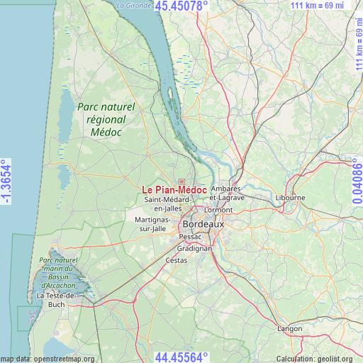
Le Pian-Médoc GPS coordinates[2]
44° 57' 19.332" North, 0° 39' 44.172" West
| Map corner | latitude | longitude |
|---|---|---|
| Upper-left | 45.45078°, | -1.3654° |
| Center: | 44.95537°, | -0.66227° |
| Lower-right: | 44.45564°, | 0.04086° |
| Map W x H: | 110.6×110.6 km | = 68.7×68.7mi |
| max Lat: | 51.07786° ⇑80% North |
| Le Pian-Médoc: | 44.95537° |
| min Lat: | ⇓20% South 41.3874° |
| min Long | Le Pian-Médoc | max Long |
| -5.08615° | -0.66227° | 9.52242° |
| W 14.9%⇐ | ⇒85.1% E |
Elevation
Elevation of Le Pian-Médoc is 23 m = 75 ft, and this is 170.7 m = 560 ft below average elevation for this country.
| Max E: |
2333 m = 7654 ft | 92.7% |
| Avg. | 193.7 m = 635 ft | |
| Le Pian-Médoc | 23 m = 75 ft | |
Min E: |
-1 m = -3 ft | 7.3% |
See also: France elevation on elevation.city.
Geographical zone
Le Pian-Médoc is located in North temperate zone (between Tropic of Cancer and the Arctic Circle). Distance of this Northern Tropic circle is 2392.6 km =1486.7 mi to South.| Distance of | km | miles | from Le Pian-Médoc |
|---|---|---|---|
| North Pole | 5008.5 | 3112.1 | to North |
| Arctic Circle | 2402.6 | 1492.9 | to North |
| Tropic Cancer | 2392.6 | 1486.7 | to South |
| Equator | 4998.6 | 3106 | to South |


Nearby cities:
15 places around Le Pian-Médoc: (largest is in red/bold)
• Arsac
5.1 km =3.2 mi,  334°
334°
• Blanquefort
5.2 km =3.2 mi,  157°
157°
• Bruges
9.3 km =5.8 mi,  154°
154°
• Cantenac
8.1 km =5 mi,  5°
5°
• Eysines
8.1 km =5 mi,  171°
171°
• Labarde
6.9 km =4.3 mi, 14°
• Le Haillan
9.3 km =5.8 mi,  188°
188°
• Le Taillan-Médoc
5.6 km =3.5 mi, 186°
• Ludon-Médoc
5.5 km =3.4 mi,  58°
58°
• Macau
6.7 km =4.2 mi,  31°
31°
• Margaux
9.5 km =5.9 mi,  352°
352°
• Parempuyre
4.6 km =2.9 mi,  96°
96°
• Saint-Aubin-de-Médoc
6.9 km =4.3 mi,  225°
225°
• Saint-Louis-de-Montferrand
10 km =6.2 mi,  93°
93°
• Saint-Médard-en-Jalles
8 km =5 mi,  215°
215°
Sources, notices
• [Note1] Compared only with cities in France existing in our database
• [Src1] Map data: © OpenStreetMap contributors (CC-BY-SA)
• [Src2] Other city data from geonames.org with taken over terms of usage.
• [Src3] Geographical zone / Annual Mean Temperature by Robert A. Rohde @ Wikipedia
