Labruyère geodata
Labruyère (Hauts-de-France) is a populated place; located in France in Europe/Paris (GMT+2) time zone. With population of 607 people, there are 13209 cities with bigger population in this country. Compared to other cities in France, 87% of cities are located further ↓South; 50.8% of cities are located further ←West and 80.6% of cities have higher elevation than Labruyère. Note1
Administrative division(s):
- Level 1: Hauts-de-France
- Level 2: Département de l'Oise
- Level 3: Arrondissement de Clermont
- Level 4: Labruyère


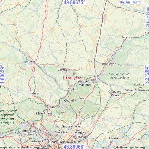
Labruyère GPS coordinates[2]
49° 21' 3.06" North, 2° 30' 34.992" East
| Map corner | latitude | longitude |
|---|---|---|
| Upper-left | 49.80675°, | 1.80659° |
| Center: | 49.35085°, | 2.50972° |
| Lower-right: | 48.89068°, | 3.21284° |
| Map W x H: | 101.9×101.9 km | = 63.3×63.3mi |
| max Lat: | 51.07786° ⇑13% North |
| Labruyère: | 49.35085° |
| min Lat: | ⇓87% South 41.3874° |
| min Long | Labruyère | max Long |
| -5.08615° | 2.50972° | 9.52242° |
| W 50.8%⇐ | ⇒49.2% E |
Elevation
Elevation of Labruyère is 53 m = 174 ft, and this is 140.7 m = 462 ft below average elevation for this country.
| Max E: |
2333 m = 7654 ft | 80.6% |
| Avg. | 193.7 m = 635 ft | |
| Labruyère | 53 m = 174 ft | |
Min E: |
-1 m = -3 ft | 19.4% |
See also: France elevation on elevation.city.
Geographical zone
Labruyère is located in North temperate zone (between Tropic of Cancer and the Arctic Circle). Distance of this North polar circle is 1913.9 km =1189.2 mi to North.| Distance of | km | miles | from Labruyère |
|---|---|---|---|
| North Pole | 4519.8 | 2808.5 | to North |
| Arctic Circle | 1913.9 | 1189.2 | to North |
| Tropic Cancer | 2881.4 | 1790.4 | to South |
| Equator | 5487.3 | 3409.6 | to South |


Nearby cities:
15 places around Labruyère: (largest is in red/bold)
• Angicourt
4.4 km =2.7 mi,  185°
185°
• Bailleval
3.9 km =2.4 mi,  262°
262°
• Brenouille
5.6 km =3.5 mi,  153°
153°
• Breuil-le-Sec
4.8 km =3 mi,  298°
298°
• Breuil-le-Vert
5.5 km =3.4 mi,  282°
282°
• Catenoy
1.9 km =1.2 mi,  1°
1°
• Cinqueux
4 km =2.5 mi,  158°
158°
• Liancourt
3.9 km =2.4 mi,  234°
234°
• Mogneville
4.8 km =3 mi,  214°
214°
• Monceaux
4.7 km =2.9 mi,  140°
140°
• Rantigny
5.5 km =3.4 mi,  242°
242°
• Rieux
5.7 km =3.5 mi,  174°
174°
• Rosoy
1.4 km =0.9 mi, 207°
• Sacy-le-Grand
2.6 km =1.6 mi,  80°
80°
• Verderonne
2.5 km =1.6 mi,  199°
199°
Sources, notices
• [Note1] Compared only with cities in France existing in our database
• [Src1] Map data: © OpenStreetMap contributors (CC-BY-SA)
• [Src2] Other city data from geonames.org with taken over terms of usage.
• [Src3] Geographical zone / Annual Mean Temperature by Robert A. Rohde @ Wikipedia
