Hottviller geodata
Hottviller (Grand Est) is a populated place; located in France in Europe/Paris (GMT+2) time zone. With population of 668 people, there are 12251 cities with bigger population in this country. Compared to other cities in France, 81.6% of cities are located further ↓South; 97% of cities are located further ←West and 83.1% of cities have lower elevation than Hottviller. Note1
Administrative division(s):
- Level 1: Grand Est
- Level 2: Moselle
- Level 3: Arrondissement de Sarreguemines
- Level 4: Hottviller


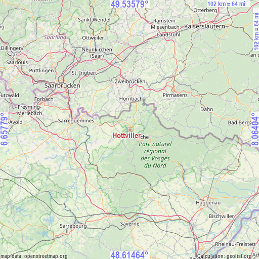
Hottviller GPS coordinates[2]
49° 4' 38.46" North, 7° 21' 39.276" East
| Map corner | latitude | longitude |
|---|---|---|
| Upper-left | 49.53579°, | 6.65779° |
| Center: | 49.07735°, | 7.36091° |
| Lower-right: | 48.61464°, | 8.06404° |
| Map W x H: | 102.4×102.4 km | = 63.6×63.6mi |
| max Lat: | 51.07786° ⇑18.4% North |
| Hottviller: | 49.07735° |
| min Lat: | ⇓81.6% South 41.3874° |
| min Long | Hottviller | max Long |
| -5.08615° | 7.36091° | 9.52242° |
| W 97%⇐ | ⇒3% E |
Elevation
Elevation of Hottviller is 323 m = 1060 ft, and this is 129.3 m = 424 ft above average elevation for this country.
| Max E: |
2333 m = 7654 ft | 16.9% |
| Hottviller | 323 m 1060 ft | |
| Avg. | 193.7 m = 635 ft | |
Min E: |
-1 m = -3 ft | 83.1% |
See also: France elevation on elevation.city.
Geographical zone
Hottviller is located in North temperate zone (between Tropic of Cancer and the Arctic Circle). Distance of this North polar circle is 1944.3 km =1208.1 mi to North.| Distance of | km | miles | from Hottviller |
|---|---|---|---|
| North Pole | 4550.2 | 2827.4 | to North |
| Arctic Circle | 1944.3 | 1208.1 | to North |
| Tropic Cancer | 2851 | 1771.5 | to South |
| Equator | 5456.9 | 3390.8 | to South |


Nearby cities:
15 places around Hottviller: (largest is in red/bold)
• Bettviller
5.6 km =3.5 mi,  272°
272°
• Bining
9.1 km =5.7 mi,  240°
240°
• Bitche
5.7 km =3.5 mi,  118°
118°
• Enchenberg
7.3 km =4.5 mi,  192°
192°
• Epping
5 km =3.1 mi,  320°
320°
• Lambach
4.7 km =2.9 mi,  181°
181°
• Lemberg
8.5 km =5.3 mi,  171°
171°
• Montbronn
10.1 km =6.3 mi,  201°
201°
• Petit-Réderching
4.7 km =2.9 mi, 237°
• Rimling
7.2 km =4.5 mi,  287°
287°
• Rohrbach-lès-Bitche
7.7 km =4.8 mi, 241°
• Saint-Louis-lès-Bitche
9.9 km =6.2 mi, 183°
• Schorbach
3.5 km =2.2 mi,  85°
85°
• Siersthal
3.9 km =2.4 mi, 192°
• Volmunster
5 km =3.1 mi,  353°
353°
Sources, notices
• [Note1] Compared only with cities in France existing in our database
• [Src1] Map data: © OpenStreetMap contributors (CC-BY-SA)
• [Src2] Other city data from geonames.org with taken over terms of usage.
• [Src3] Geographical zone / Annual Mean Temperature by Robert A. Rohde @ Wikipedia
