Duravel geodata
Duravel (Occitanie) is a populated place; located in France in Europe/Paris (GMT+2) time zone. With population of 941 people, there are 9290 cities with bigger population in this country. Compared to other cities in France, 83.5% of cities are located further ↑North; 68.1% of cities are located further →East and 59.1% of cities have higher elevation than Duravel. Note1
Administrative division(s):
- Level 1: Occitanie
- Level 2: Lot
- Level 3: Arrondissement de Cahors
- Level 4: Duravel


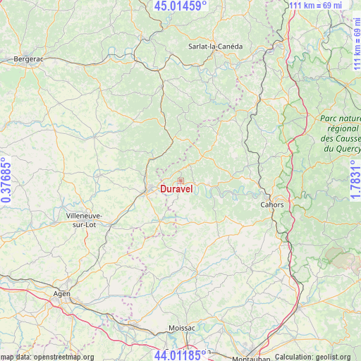
Duravel GPS coordinates[2]
44° 30' 55.368" North, 1° 4' 47.892" East
| Map corner | latitude | longitude |
|---|---|---|
| Upper-left | 45.01459°, | 0.37685° |
| Center: | 44.51538°, | 1.07997° |
| Lower-right: | 44.01185°, | 1.7831° |
| Map W x H: | 111.5×111.5 km | = 69.3×69.3mi |
| max Lat: | 51.07786° ⇑83.5% North |
| Duravel: | 44.51538° |
| min Lat: | ⇓16.5% South 41.3874° |
| min Long | Duravel | max Long |
| -5.08615° | 1.07997° | 9.52242° |
| W 31.9%⇐ | ⇒68.1% E |
Elevation
Elevation of Duravel is 105 m = 344 ft, and this is 88.7 m = 291 ft below average elevation for this country.
| Max E: |
2333 m = 7654 ft | 59.1% |
| Avg. | 193.7 m = 635 ft | |
| Duravel | 105 m = 344 ft | |
Min E: |
-1 m = -3 ft | 40.9% |
See also: France elevation on elevation.city.
Geographical zone
Duravel is located in North temperate zone (between Tropic of Cancer and the Arctic Circle). Distance of this Northern Tropic circle is 2343.7 km =1456.3 mi to South.| Distance of | km | miles | from Duravel |
|---|---|---|---|
| North Pole | 5057.4 | 3142.5 | to North |
| Arctic Circle | 2451.5 | 1523.3 | to North |
| Tropic Cancer | 2343.7 | 1456.3 | to South |
| Equator | 4949.6 | 3075.5 | to South |


Nearby cities:
15 places around Duravel: (largest is in red/bold)
• Albas
13.5 km =8.4 mi,  112°
112°
• Blanquefort-sur-Briolance
12.8 km =8 mi,  315°
315°
• Condezaygues
13.5 km =8.4 mi,  255°
255°
• Cuzorn
10.9 km =6.8 mi,  285°
285°
• Fumel
9.3 km =5.8 mi, 258°
• Monsempron-Libos
11.4 km =7.1 mi, 255°
• Montayral
8.6 km =5.3 mi,  238°
238°
• Prayssac
8.7 km =5.4 mi,  98°
98°
• Puy-l’Évêque
4.9 km =3 mi, 103°
• Saint-Front-sur-Lémance
10.7 km =6.6 mi,  307°
307°
• Saint-Georges
14.2 km =8.8 mi,  234°
234°
• Saint-Vite
12.2 km =7.6 mi,  246°
246°
• Sauveterre-la-Lémance
10 km =6.2 mi,  327°
327°
• Soturac
6.1 km =3.8 mi, 238°
• Villefranche-du-Périgord
12.6 km =7.8 mi,  0°
0°
Sources, notices
• [Note1] Compared only with cities in France existing in our database
• [Src1] Map data: © OpenStreetMap contributors (CC-BY-SA)
• [Src2] Other city data from geonames.org with taken over terms of usage.
• [Src3] Geographical zone / Annual Mean Temperature by Robert A. Rohde @ Wikipedia
