Bourneville geodata
Bourneville (Normandy) is a populated place; located in France in Europe/Paris (GMT+2) time zone. With population of 774 people, there are 10892 cities with bigger population in this country. Compared to other cities in France, 87.7% of cities are located further ↓South; 72.2% of cities are located further →East and 51.2% of cities have higher elevation than Bourneville. Note1
Administrative division(s):
- Level 1: Normandy
- Level 2: Département de l'Eure
- Level 3: Arrondissement de Bernay
- Level 4: Bourneville-Sainte-Croix


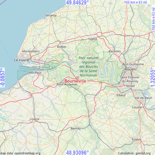
Bourneville GPS coordinates[2]
49° 23' 26.736" North, 0° 37' 2.712" East
| Map corner | latitude | longitude |
|---|---|---|
| Upper-left | 49.84629°, | -0.0857° |
| Center: | 49.39076°, | 0.61742° |
| Lower-right: | 48.93096°, | 1.32055° |
| Map W x H: | 101.8×101.8 km | = 63.3×63.3mi |
| max Lat: | 51.07786° ⇑12.3% North |
| Bourneville: | 49.39076° |
| min Lat: | ⇓87.7% South 41.3874° |
| min Long | Bourneville | max Long |
| -5.08615° | 0.61742° | 9.52242° |
| W 27.8%⇐ | ⇒72.2% E |
Elevation
Elevation of Bourneville is 128 m = 420 ft, and this is 65.7 m = 216 ft below average elevation for this country.
| Max E: |
2333 m = 7654 ft | 51.2% |
| Avg. | 193.7 m = 635 ft | |
| Bourneville | 128 m = 420 ft | |
Min E: |
-1 m = -3 ft | 48.8% |
See also: France elevation on elevation.city.
Geographical zone
Bourneville is located in North temperate zone (between Tropic of Cancer and the Arctic Circle). Distance of this North polar circle is 1909.4 km =1186.4 mi to North.| Distance of | km | miles | from Bourneville |
|---|---|---|---|
| North Pole | 4515.3 | 2805.7 | to North |
| Arctic Circle | 1909.4 | 1186.4 | to North |
| Tropic Cancer | 2885.8 | 1793.2 | to South |
| Equator | 5491.7 | 3412.4 | to South |


Nearby cities:
15 places around Bourneville: (largest is in red/bold)
• Appeville-Annebault
9.2 km =5.7 mi,  165°
165°
• Campigny
10.1 km =6.3 mi,  207°
207°
• Corneville-sur-Risle
5.9 km =3.7 mi,  202°
202°
• Fourmetot
3.5 km =2.2 mi,  251°
251°
• Illeville-sur-Montfort
10.7 km =6.6 mi,  132°
132°
• Manneville-sur-Risle
6.8 km =4.2 mi,  230°
230°
• Norville
9.9 km =6.2 mi,  10°
10°
• Petiville
8.1 km =5 mi,  344°
344°
• Pont-Audemer
8.6 km =5.3 mi,  238°
238°
• Routot
8.5 km =5.3 mi,  99°
99°
• Saint-Germain-Village
9.5 km =5.9 mi, 240°
• Saint-Mards-de-Blacarville
7.3 km =4.5 mi, 252°
• Tourville-sur-Pont-Audemer
10.2 km =6.3 mi, 226°
• Trouville-la-Haule
4.3 km =2.7 mi,  317°
317°
• Étréville
3.1 km =1.9 mi, 132°
Sources, notices
• [Note1] Compared only with cities in France existing in our database
• [Src1] Map data: © OpenStreetMap contributors (CC-BY-SA)
• [Src2] Other city data from geonames.org with taken over terms of usage.
• [Src3] Geographical zone / Annual Mean Temperature by Robert A. Rohde @ Wikipedia
