Blanzac-Porcheresse geodata
Blanzac-Porcheresse (Nouvelle-Aquitaine) is a populated place; located in France in Europe/Paris (GMT+2) time zone. With population of 836 people, there are 10228 cities with bigger population in this country. Compared to other cities in France, 74.3% of cities are located further ↑North; 77.9% of cities are located further →East and 55.9% of cities have higher elevation than Blanzac-Porcheresse. Note1
Administrative division(s):
- Level 1: Nouvelle-Aquitaine
- Level 2: Charente
- Level 3: Arrondissement de Cognac
- Level 4: Coteaux-du-Blanzacais


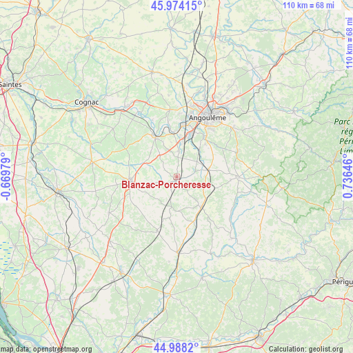
Blanzac-Porcheresse GPS coordinates[2]
45° 28' 59.988" North, 0° 1' 59.988" East
| Map corner | latitude | longitude |
|---|---|---|
| Upper-left | 45.97415°, | -0.66979° |
| Center: | 45.48333°, | 0.03333° |
| Lower-right: | 44.9882°, | 0.73646° |
| Map W x H: | 109.6×109.6 km | = 68.1×68.1mi |
| max Lat: | 51.07786° ⇑74.3% North |
| Blanzac-Porcheresse: | 45.48333° |
| min Lat: | ⇓25.7% South 41.3874° |
| min Long | Blanzac-Porcher | max Long |
| -5.08615° | 0.03333° | 9.52242° |
| W 22.1%⇐ | ⇒77.9% E |
Elevation
Elevation of Blanzac-Porcheresse is 114 m = 374 ft, and this is 79.7 m = 261 ft below average elevation for this country.
| Max E: |
2333 m = 7654 ft | 55.9% |
| Avg. | 193.7 m = 635 ft | |
| Blanzac-Porcheresse | 114 m = 374 ft | |
Min E: |
-1 m = -3 ft | 44.1% |
See also: France elevation on elevation.city.
Geographical zone
Blanzac-Porcheresse is located in North temperate zone (between Tropic of Cancer and the Arctic Circle). Distance of this North polar circle is 2343.9 km =1456.4 mi to North.| Distance of | km | miles | from Blanzac-Porcheresse |
|---|---|---|---|
| North Pole | 4949.8 | 3075.7 | to North |
| Arctic Circle | 2343.9 | 1456.4 | to North |
| Tropic Cancer | 2451.4 | 1523.2 | to South |
| Equator | 5057.3 | 3142.5 | to South |


Nearby cities:
15 places around Blanzac-Porcheresse: (largest is in red/bold)
• Barbezieux-Saint-Hilaire
14.5 km =9 mi,  265°
265°
• Châteauneuf-sur-Charente
14.5 km =9 mi,  333°
333°
• Claix
7.5 km =4.7 mi,  9°
9°
• Condéon
16 km =9.9 mi,  234°
234°
• Fouquebrune
14.1 km =8.8 mi,  66°
66°
• Jurignac
7.6 km =4.7 mi,  316°
316°
• La Couronne
15.1 km =9.4 mi,  19°
19°
• Montmoreau-Saint-Cybard
12.1 km =7.5 mi,  139°
139°
• Mouthiers-sur-Boëme
9.9 km =6.2 mi,  41°
41°
• Ronsenac
15.6 km =9.7 mi,  90°
90°
• Roullet-Saint-Estèphe
11.2 km =7 mi, 6°
• Saint-Amant-de-Montmoreau
13 km =8.1 mi, 135°
• Sireuil
14.9 km =9.3 mi,  354°
354°
• Trois-Palis
16.7 km =10.4 mi,  4°
4°
• Vœuil-et-Giget
14.4 km =8.9 mi, 39°
Sources, notices
• [Note1] Compared only with cities in France existing in our database
• [Src1] Map data: © OpenStreetMap contributors (CC-BY-SA)
• [Src2] Other city data from geonames.org with taken over terms of usage.
• [Src3] Geographical zone / Annual Mean Temperature by Robert A. Rohde @ Wikipedia
