Biot geodata
Biot (Provence-Alpes-Côte d'Azur) is a populated place; located in France in Europe/Paris (GMT+2) time zone. With population of 7,737 people, there are 1251 cities with bigger population in this country. Compared to other cities in France, 91.5% of cities are located further ↑North; 95.2% of cities are located further ←West and 72.6% of cities have higher elevation than Biot. Note1
Administrative division(s):
- Level 1: Provence-Alpes-Côte d'Azur
- Level 2: Alpes-Maritimes
- Level 3: Arrondissement de Grasse
- Level 4: Biot


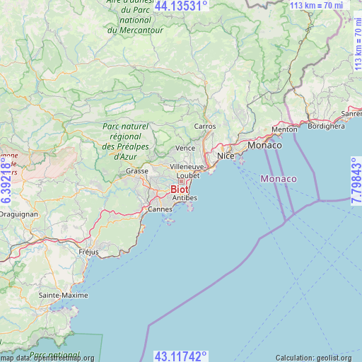
Biot GPS coordinates[2]
43° 37' 42.672" North, 7° 5' 43.08" East
| Map corner | latitude | longitude |
|---|---|---|
| Upper-left | 44.13531°, | 6.39218° |
| Center: | 43.62852°, | 7.0953° |
| Lower-right: | 43.11742°, | 7.79843° |
| Map W x H: | 113.2×113.2 km | = 70.3×70.3mi |
| max Lat: | 51.07786° ⇑91.5% North |
| Biot: | 43.62852° |
| min Lat: | ⇓8.5% South 41.3874° |
| min Long | Biot | max Long |
| -5.08615° | 7.0953° | 9.52242° |
| W 95.2%⇐ | ⇒4.8% E |
Elevation
Elevation of Biot is 72 m = 236 ft, and this is 121.7 m = 399 ft below average elevation for this country.
| Max E: |
2333 m = 7654 ft | 72.6% |
| Avg. | 193.7 m = 635 ft | |
| Biot | 72 m = 236 ft | |
Min E: |
-1 m = -3 ft | 27.4% |
See also: France elevation on elevation.city.
Geographical zone
Biot is located in North temperate zone (between Tropic of Cancer and the Arctic Circle). Distance of this Northern Tropic circle is 2245.1 km =1395 mi to South.| Distance of | km | miles | from Biot |
|---|---|---|---|
| North Pole | 5156 | 3203.8 | to North |
| Arctic Circle | 2550.1 | 1584.6 | to North |
| Tropic Cancer | 2245.1 | 1395 | to South |
| Equator | 4851 | 3014.3 | to South |


Nearby cities:
15 places around Biot: (largest is in red/bold)
• Antibes
4.9 km =3 mi,  167°
167°
• Cagnes-sur-Mer
5.7 km =3.5 mi,  47°
47°
• Châteauneuf-Grasse
10 km =6.2 mi,  295°
295°
• La Colle-sur-Loup
6.5 km =4 mi,  6°
6°
• Le Cannet
8.4 km =5.2 mi,  226°
226°
• Le Rouret
8.5 km =5.3 mi,  310°
310°
• Mouans-Sartoux
10 km =6.2 mi,  265°
265°
• Mougins
8.6 km =5.3 mi,  248°
248°
• Opio
10.1 km =6.3 mi, 296°
• Saint-Laurent-du-Var
9.1 km =5.7 mi,  56°
56°
• Saint-Paul-de-Vence
8.1 km =5 mi, 12°
• Tourrettes-sur-Loup
10.1 km =6.3 mi,  343°
343°
• Valbonne
7.8 km =4.8 mi, 273°
• Vallauris
6.5 km =4 mi,  210°
210°
• Villeneuve-Loubet
3.9 km =2.4 mi,  33°
33°
Sources, notices
• [Note1] Compared only with cities in France existing in our database
• [Src1] Map data: © OpenStreetMap contributors (CC-BY-SA)
• [Src2] Other city data from geonames.org with taken over terms of usage.
• [Src3] Geographical zone / Annual Mean Temperature by Robert A. Rohde @ Wikipedia
