Billère geodata
Billère (Nouvelle-Aquitaine) is a populated place; located in France in Europe/Paris (GMT+2) time zone. With population of 14,914 people, there are 640 cities with bigger population in this country. Compared to other cities in France, 95.7% of cities are located further ↑North; 82.1% of cities are located further →East and 60% of cities have lower elevation than Billère. Note1
Administrative division(s):
- Level 1: Nouvelle-Aquitaine
- Level 2: Département des Pyrénées-Atlantiques
- Level 3: Arrondissement de Pau
- Level 4: Billère


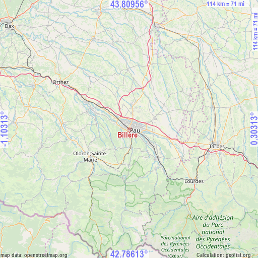
Billère GPS coordinates[2]
43° 18' 0" North, 0° 24' 0" West
| Map corner | latitude | longitude |
|---|---|---|
| Upper-left | 43.80956°, | -1.10313° |
| Center: | 43.3°, | -0.4° |
| Lower-right: | 42.78613°, | 0.30313° |
| Map W x H: | 113.8×113.8 km | = 70.7×70.7mi |
| max Lat: | 51.07786° ⇑95.7% North |
| Billère: | 43.3° |
| min Lat: | ⇓4.3% South 41.3874° |
| min Long | Billère | max Long |
| -5.08615° | -0.4° | 9.52242° |
| W 17.9%⇐ | ⇒82.1% E |
Elevation
Elevation of Billère is 170 m = 558 ft, and this is 23.7 m = 78 ft below average elevation for this country.
| Max E: |
2333 m = 7654 ft | 40% |
| Avg. | 193.7 m = 635 ft | |
| Billère | 170 m = 558 ft | |
Min E: |
-1 m = -3 ft | 60% |
See also: France elevation on elevation.city.
Geographical zone
Billère is located in North temperate zone (between Tropic of Cancer and the Arctic Circle). Distance of this Northern Tropic circle is 2208.6 km =1372.4 mi to South.| Distance of | km | miles | from Billère |
|---|---|---|---|
| North Pole | 5192.6 | 3226.5 | to North |
| Arctic Circle | 2586.7 | 1607.3 | to North |
| Tropic Cancer | 2208.6 | 1372.4 | to South |
| Equator | 4814.5 | 2991.6 | to South |


Nearby cities:
15 places around Billère: (largest is in red/bold)
• Aressy
7 km =4.3 mi,  105°
105°
• Artiguelouve
5.7 km =3.5 mi,  288°
288°
• Bizanos
4.5 km =2.8 mi, 114°
• Gan
7.5 km =4.7 mi,  169°
169°
• Gelos
3.3 km =2.1 mi,  124°
124°
• Idron
7 km =4.3 mi, 105°
• Jurançon
1.7 km =1.1 mi,  140°
140°
• Laroin
2.7 km =1.7 mi,  270°
270°
• Lescar
3.9 km =2.4 mi,  340°
340°
• Lons
1.9 km =1.2 mi,  0°
0°
• Mazères-Lezons
5.5 km =3.4 mi,  132°
132°
• Pau
2.7 km =1.7 mi,  90°
90°
• Rontignon
6.5 km =4 mi, 124°
• Saint-Faust
5.5 km =3.4 mi,  227°
227°
• Uzos
6.5 km =4 mi, 124°
Sources, notices
• [Note1] Compared only with cities in France existing in our database
• [Src1] Map data: © OpenStreetMap contributors (CC-BY-SA)
• [Src2] Other city data from geonames.org with taken over terms of usage.
• [Src3] Geographical zone / Annual Mean Temperature by Robert A. Rohde @ Wikipedia
