Béthencourt-sur-Mer geodata
Béthencourt-sur-Mer (Hauts-de-France) is a populated place; located in France in Europe/Paris (GMT+2) time zone. With population of 1,020 people, there are 8683 cities with bigger population in this country. Compared to other cities in France, 94% of cities are located further ↓South; 63% of cities are located further →East and 59.4% of cities have higher elevation than Béthencourt-sur-Mer. Note1
Administrative division(s):
- Level 1: Hauts-de-France
- Level 2: Somme
- Level 3: Abbeville
- Level 4: Béthencourt-sur-Mer


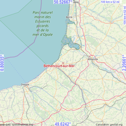
Béthencourt-sur-Mer GPS coordinates[2]
50° 4' 39.216" North, 1° 30' 12.528" East
| Map corner | latitude | longitude |
|---|---|---|
| Upper-left | 50.52667°, | 0.80035° |
| Center: | 50.07756°, | 1.50348° |
| Lower-right: | 49.6242°, | 2.20661° |
| Map W x H: | 100.3×100.3 km | = 62.3×62.3mi |
| max Lat: | 51.07786° ⇑6% North |
| Béthencourt-sur-Mer: | 50.07756° |
| min Lat: | ⇓94% South 41.3874° |
| min Long | Béthencourt-su | max Long |
| -5.08615° | 1.50348° | 9.52242° |
| W 37%⇐ | ⇒63% E |
Elevation
Elevation of Béthencourt-sur-Mer is 104 m = 341 ft, and this is 89.7 m = 294 ft below average elevation for this country.
| Max E: |
2333 m = 7654 ft | 59.4% |
| Avg. | 193.7 m = 635 ft | |
| Béthencourt-sur-Mer | 104 m = 341 ft | |
Min E: |
-1 m = -3 ft | 40.6% |
See also: France elevation on elevation.city.
Geographical zone
Béthencourt-sur-Mer is located in North temperate zone (between Tropic of Cancer and the Arctic Circle). Distance of this North polar circle is 1833.1 km =1139 mi to North.| Distance of | km | miles | from Béthencourt-sur-Mer |
|---|---|---|---|
| North Pole | 4439 | 2758.3 | to North |
| Arctic Circle | 1833.1 | 1139 | to North |
| Tropic Cancer | 2962.2 | 1840.6 | to South |
| Equator | 5568.1 | 3459.9 | to South |


Nearby cities:
15 places around Béthencourt-sur-Mer: (largest is in red/bold)
• Ault
4.8 km =3 mi,  307°
307°
• Belloy
3.3 km =2.1 mi,  53°
53°
• Bourseville
3.5 km =2.2 mi,  27°
27°
• Bouvaincourt-sur-Bresle
5.3 km =3.3 mi,  188°
188°
• Dargnies
4.3 km =2.7 mi,  158°
158°
• Embreville
6.1 km =3.8 mi,  153°
153°
• Eu
6.9 km =4.3 mi,  239°
239°
• Fressenneville
5.4 km =3.4 mi,  100°
100°
• Friaucourt
2.3 km =1.4 mi,  302°
302°
• Friville-Escarbotin
3.1 km =1.9 mi,  72°
72°
• Nibas
6.7 km =4.2 mi, 65°
• Tully
1.4 km =0.9 mi, 47°
• Woignarue
3.7 km =2.3 mi,  350°
350°
• Woincourt
2.7 km =1.7 mi,  117°
117°
• Yzengremer
2.2 km =1.4 mi,  143°
143°
Sources, notices
• [Note1] Compared only with cities in France existing in our database
• [Src1] Map data: © OpenStreetMap contributors (CC-BY-SA)
• [Src2] Other city data from geonames.org with taken over terms of usage.
• [Src3] Geographical zone / Annual Mean Temperature by Robert A. Rohde @ Wikipedia
