Armentières-en-Brie geodata
Armentières-en-Brie (Île-de-France) is a populated place; located in France in Europe/Paris (GMT+2) time zone. With population of 1,321 people, there are 6934 cities with bigger population in this country. Compared to other cities in France, 79.2% of cities are located further ↓South; 58.1% of cities are located further ←West and 76.2% of cities have higher elevation than Armentières-en-Brie. Note1
Administrative division(s):
- Level 1: Île-de-France
- Level 2: Seine-et-Marne
- Level 3: Arrondissement de Meaux
- Level 4: Armentières-en-Brie


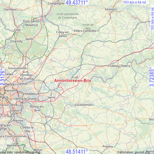
Armentières-en-Brie GPS coordinates[2]
48° 58' 39.9" North, 3° 1' 14.628" East
| Map corner | latitude | longitude |
|---|---|---|
| Upper-left | 49.43711°, | 2.3176° |
| Center: | 48.97775°, | 3.02073° |
| Lower-right: | 48.51411°, | 3.72385° |
| Map W x H: | 102.6×102.6 km | = 63.8×63.8mi |
| max Lat: | 51.07786° ⇑20.8% North |
| Armentières-en-Brie: | 48.97775° |
| min Lat: | ⇓79.2% South 41.3874° |
| min Long | Armentières-en | max Long |
| -5.08615° | 3.02073° | 9.52242° |
| W 58.1%⇐ | ⇒41.9% E |
Elevation
Elevation of Armentières-en-Brie is 64 m = 210 ft, and this is 129.7 m = 426 ft below average elevation for this country.
| Max E: |
2333 m = 7654 ft | 76.2% |
| Avg. | 193.7 m = 635 ft | |
| Armentières-en-Brie | 64 m = 210 ft | |
Min E: |
-1 m = -3 ft | 23.8% |
See also: France elevation on elevation.city.
Geographical zone
Armentières-en-Brie is located in North temperate zone (between Tropic of Cancer and the Arctic Circle). Distance of this North polar circle is 1955.4 km =1215 mi to North.| Distance of | km | miles | from Armentières-en-Brie |
|---|---|---|---|
| North Pole | 4561.2 | 2834.2 | to North |
| Arctic Circle | 1955.4 | 1215 | to North |
| Tropic Cancer | 2839.9 | 1764.6 | to South |
| Equator | 5445.8 | 3383.9 | to South |


Nearby cities:
15 places around Armentières-en-Brie: (largest is in red/bold)
• Changis-sur-Marne
2.2 km =1.4 mi,  177°
177°
• Cocherel
7.7 km =4.8 mi,  51°
51°
• Congis-sur-Thérouanne
3.7 km =2.3 mi,  312°
312°
• Fublaines
7.6 km =4.7 mi,  234°
234°
• Isles-les-Meldeuses
2.6 km =1.6 mi,  336°
336°
• Lizy-sur-Ourcq
5.2 km =3.2 mi,  0°
0°
• Mary-sur-Marne
4.3 km =2.7 mi,  7°
7°
• Montceaux-lès-Meaux
4.6 km =2.9 mi,  209°
209°
• Poincy
6.2 km =3.9 mi,  261°
261°
• Saint-Jean-les-Deux-Jumeaux
2.9 km =1.8 mi, 181°
• Sammeron
5.7 km =3.5 mi,  126°
126°
• Signy-Signets
6.5 km =4 mi,  148°
148°
• Trilport
5.6 km =3.5 mi,  245°
245°
• Ussy-sur-Marne
4.5 km =2.8 mi,  121°
121°
• Varreddes
7.3 km =4.5 mi,  292°
292°
Sources, notices
• [Note1] Compared only with cities in France existing in our database
• [Src1] Map data: © OpenStreetMap contributors (CC-BY-SA)
• [Src2] Other city data from geonames.org with taken over terms of usage.
• [Src3] Geographical zone / Annual Mean Temperature by Robert A. Rohde @ Wikipedia
