Arenc geodata
Arenc (Provence-Alpes-Côte d'Azur) is a section of populated place; located in France in Europe/Paris (GMT+2) time zone. With population of 1,645 people, there are 5680 cities with bigger population in this country. Compared to other cities in France, 95.3% of cities are located further ↑North; 81.3% of cities are located further ←West and 93.9% of cities have higher elevation than Arenc. Note1
Administrative division(s):
- Level 1: Provence-Alpes-Côte d'Azur
- Level 2: Département des Bouches-du-Rhône
- Level 3: Arrondissement de Marseille
- Level 4: Marseille


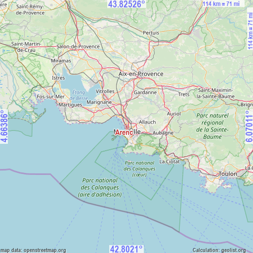
Arenc GPS coordinates[2]
43° 18' 56.988" North, 5° 22' 1.128" East
| Map corner | latitude | longitude |
|---|---|---|
| Upper-left | 43.82526°, | 4.66386° |
| Center: | 43.31583°, | 5.36698° |
| Lower-right: | 42.8021°, | 6.07011° |
| Map W x H: | 113.8×113.8 km | = 70.7×70.7mi |
| max Lat: | 51.07786° ⇑95.3% North |
| Arenc: | 43.31583° |
| min Lat: | ⇓4.7% South 41.3874° |
| min Long | Arenc | max Long |
| -5.08615° | 5.36698° | 9.52242° |
| W 81.3%⇐ | ⇒18.7% E |
Elevation
Elevation of Arenc is 20 m = 66 ft, and this is 173.7 m = 570 ft below average elevation for this country.
| Max E: |
2333 m = 7654 ft | 93.9% |
| Avg. | 193.7 m = 635 ft | |
| Arenc | 20 m = 66 ft | |
Min E: |
-1 m = -3 ft | 6.1% |
See also: France elevation on elevation.city.
Geographical zone
Arenc is located in North temperate zone (between Tropic of Cancer and the Arctic Circle). Distance of this Northern Tropic circle is 2210.3 km =1373.4 mi to South.| Distance of | km | miles | from Arenc |
|---|---|---|---|
| North Pole | 5190.8 | 3225.4 | to North |
| Arctic Circle | 2584.9 | 1606.2 | to North |
| Tropic Cancer | 2210.3 | 1373.4 | to South |
| Equator | 4816.3 | 2992.7 | to South |


Nearby cities:
15 places around Arenc: (largest is in red/bold)
• Belle de Mai
1.6 km =1 mi,  106°
106°
• Belsunce
2.1 km =1.3 mi,  158°
158°
• Bon-Secours
1.4 km =0.9 mi,  74°
74°
• La Cabucelle
1.8 km =1.1 mi,  345°
345°
• La Joliette
1.2 km =0.7 mi,  181°
181°
• La Villette
0.7 km =0.4 mi,  128°
128°
• Le Canet
1.2 km =0.7 mi,  20°
20°
• Le Chapitre
2.2 km =1.4 mi,  140°
140°
• Les Crottes
0.8 km =0.5 mi,  6°
6°
• Les Grands Carmes
1.8 km =1.1 mi, 164°
• Marseille 02
2.2 km =1.4 mi,  172°
172°
• Marseille 03
1.6 km =1 mi,  154°
154°
• Saint-Charles
2.1 km =1.3 mi, 138°
• Saint-Lazare
1.3 km =0.8 mi, 152°
• Saint-Mauront
0.7 km =0.4 mi,  92°
92°
Sources, notices
• [Note1] Compared only with cities in France existing in our database
• [Src1] Map data: © OpenStreetMap contributors (CC-BY-SA)
• [Src2] Other city data from geonames.org with taken over terms of usage.
• [Src3] Geographical zone / Annual Mean Temperature by Robert A. Rohde @ Wikipedia
