York geodata
York (England) is a seat of a second-order administrative division; located in United Kingdom in Europe/London (GMT+1) time zone. With population of 153,717 people, there are 57 cities with bigger population in this country. Compared to other cities in United Kingdom, 78.1% of cities are located further ↓South; 65.1% of cities are located further ←West and 83.6% of cities have higher elevation than York. Note1


York GPS coordinates[2]
53° 57' 27.468" North, 1° 4' 57.756" West
| Map corner | latitude | longitude |
|---|---|---|
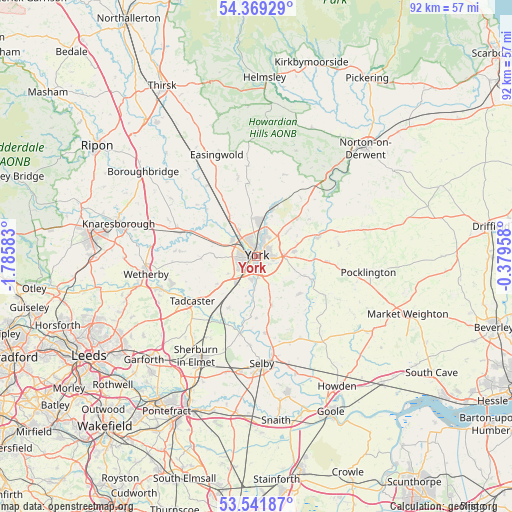
| Upper-left | 54.36929°, | -1.78583° |
| Center: | 53.95763°, | -1.08271° |
| Lower-right: | 53.54187°, | -0.37958° |
| Map W x H: | 92×92 km | = 57.2×57.2mi |
| max Lat: | 60.39635° ⇑21.9% North |
| York: | 53.95763° |
| min Lat: | ⇓78.1% South 34.60088° |
| min Long | York | max Long |
| -7.64133° | -1.08271° | 32.95536° |
| W 65.1%⇐ | ⇒34.9% E |
Elevation
Elevation of York is 17 m = 56 ft, and this is 55.9 m = 183 ft below average elevation for this country.
| Max E: |
515 m = 1690 ft | 83.6% |
| Avg. | 72.9 m = 239 ft | |
| York | 17 m = 56 ft | |
Min E: |
-30 m = -98 ft | 16.4% |
See also: York elevation on elevation.city.
Geographical zone
York is located in North temperate zone (between Tropic of Cancer and the Arctic Circle). Distance of this North polar circle is 1401.6 km =870.9 mi to North.| Distance of | km | miles | from York |
|---|---|---|---|
| North Pole | 4007.5 | 2490.1 | to North |
| Arctic Circle | 1401.6 | 870.9 | to North |
| Tropic Cancer | 3393.6 | 2108.7 | to South |
| Equator | 5999.5 | 3727.9 | to South |


Nearby cities:
15 places around York: (largest is in red/bold)
• Askham Bryan
6.1 km =3.8 mi,  238°
238°
• Bishopthorpe
4.4 km =2.7 mi,  194°
194°
• Copmanthorpe
6.2 km =3.9 mi,  218°
218°
• Deighton
6.8 km =4.2 mi,  161°
161°
• Fulford
2.9 km =1.8 mi, 158°
• Haxby
6.3 km =3.9 mi,  6°
6°
• Heslington
2.5 km =1.6 mi,  119°
119°
• Huntington
5.2 km =3.2 mi,  24°
24°
• Murton
4.8 km =3 mi,  78°
78°
• Nether Poppleton
5.6 km =3.5 mi,  307°
307°
• Rufforth
7.2 km =4.5 mi,  267°
267°
• Skelton
5.8 km =3.6 mi,  324°
324°
• Stockton on the Forest
6.8 km =4.2 mi,  50°
50°
• Upper Poppleton
5.1 km =3.2 mi,  297°
297°
• Wigginton
6.6 km =4.1 mi,  359°
359°
Sources, notices
• [Note1] Compared only with cities in United Kingdom existing in our database
• [Src1] Map data: © OpenStreetMap contributors (CC-BY-SA)
• [Src2] Other city data from geonames.org with taken over terms of usage.
• [Src3] Geographical zone / Annual Mean Temperature by Robert A. Rohde @ Wikipedia
