Wrexham geodata
Wrexham (Wales) is a seat of a second-order administrative division; located in United Kingdom in Europe/London (GMT+1) time zone. With population of 65,692 people, there are 160 cities with bigger population in this country. Compared to other cities in United Kingdom, 61.3% of cities are located further ↓South; 75.1% of cities are located further →East and 65.3% of cities have lower elevation than Wrexham. Note1


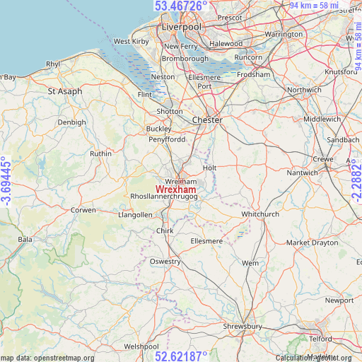
Wrexham GPS coordinates[2]
53° 2' 47.904" North, 2° 59' 28.752" West
| Map corner | latitude | longitude |
|---|---|---|
| Upper-left | 53.46726°, | -3.69445° |
| Center: | 53.04664°, | -2.99132° |
| Lower-right: | 52.62187°, | -2.2882° |
| Map W x H: | 94×94 km | = 58.4×58.4mi |
| max Lat: | 60.39635° ⇑38.7% North |
| Wrexham: | 53.04664° |
| min Lat: | ⇓61.3% South 34.60088° |
| min Long | Wrexham | max Long |
| -7.64133° | -2.99132° | 32.95536° |
| W 24.9%⇐ | ⇒75.1% E |
Elevation
Elevation of Wrexham is 87 m = 285 ft, and this is 14.1 m = 46 ft above average elevation for this country.
| Max E: |
515 m = 1690 ft | 34.7% |
| Wrexham | 87 m 285 ft | |
| Avg. | 72.9 m = 239 ft | |
Min E: |
-30 m = -98 ft | 65.3% |
See also: Wrexham elevation on elevation.city.
Geographical zone
Wrexham is located in North temperate zone (between Tropic of Cancer and the Arctic Circle). Distance of this North polar circle is 1502.9 km =933.9 mi to North.| Distance of | km | miles | from Wrexham |
|---|---|---|---|
| North Pole | 4108.8 | 2553.1 | to North |
| Arctic Circle | 1502.9 | 933.9 | to North |
| Tropic Cancer | 3292.3 | 2045.7 | to South |
| Equator | 5898.2 | 3665 | to South |


Nearby cities:
15 places around Wrexham: (largest is in red/bold)
• Brymbo
5.5 km =3.4 mi,  293°
293°
• Caergwrle
7.7 km =4.8 mi,  335°
335°
• Coedpoeth
4.8 km =3 mi,  279°
279°
• Dodleston
11.2 km =7 mi,  12°
12°
• Farndon
8.8 km =5.5 mi,  62°
62°
• Gresford
4.5 km =2.8 mi,  17°
17°
• Holt
7.6 km =4.7 mi,  72°
72°
• Hope
8.3 km =5.2 mi, 340°
• Leeswood
11.9 km =7.4 mi,  324°
324°
• Marchwiel
3.2 km =2 mi,  141°
141°
• Overton
9.7 km =6 mi,  156°
156°
• Rhosllanerchrugog
6.1 km =3.8 mi,  227°
227°
• Rossett
7.6 km =4.7 mi, 24°
• Ruabon
7.3 km =4.5 mi,  205°
205°
• Treuddyn
11.5 km =7.1 mi,  311°
311°
Sources, notices
• [Note1] Compared only with cities in United Kingdom existing in our database
• [Src1] Map data: © OpenStreetMap contributors (CC-BY-SA)
• [Src2] Other city data from geonames.org with taken over terms of usage.
• [Src3] Geographical zone / Annual Mean Temperature by Robert A. Rohde @ Wikipedia
