Wragby geodata
Wragby (England) is a populated place; located in United Kingdom in Europe/London (GMT+1) time zone. With population of 1,768 people, there are 2799 cities with bigger population in this country. Compared to other cities in United Kingdom, 65.5% of cities are located further ↓South; 81% of cities are located further ←West and 75.4% of cities have higher elevation than Wragby. Note1
Administrative division(s):
- Level 1: England
- Level 2: Lincolnshire
- Level 3: East Lindsey District
- Level 4: Wragby


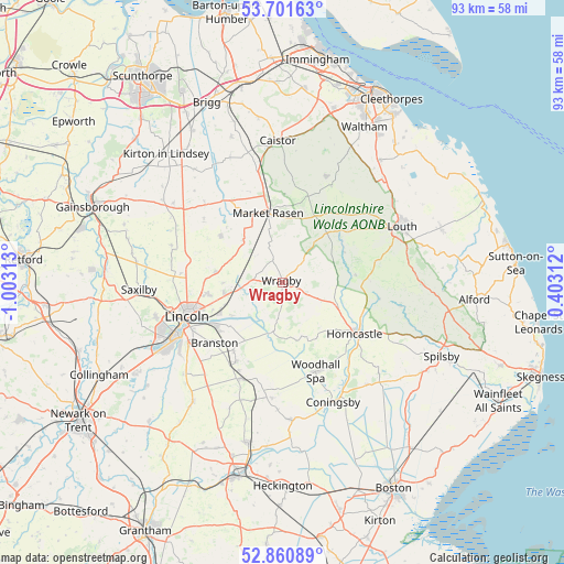
Wragby GPS coordinates[2]
53° 16' 59.988" North, 0° 18' 0" West
| Map corner | latitude | longitude |
|---|---|---|
| Upper-left | 53.70163°, | -1.00313° |
| Center: | 53.28333°, | -0.3° |
| Lower-right: | 52.86089°, | 0.40312° |
| Map W x H: | 93.5×93.5 km | = 58.1×58.1mi |
| max Lat: | 60.39635° ⇑34.5% North |
| Wragby: | 53.28333° |
| min Lat: | ⇓65.5% South 34.60088° |
| min Long | Wragby | max Long |
| -7.64133° | -0.3° | 32.95536° |
| W 81%⇐ | ⇒19% E |
Elevation
Elevation of Wragby is 26 m = 85 ft, and this is 46.9 m = 154 ft below average elevation for this country.
| Max E: |
515 m = 1690 ft | 75.4% |
| Avg. | 72.9 m = 239 ft | |
| Wragby | 26 m = 85 ft | |
Min E: |
-30 m = -98 ft | 24.6% |
See also: United Kingdom elevation on elevation.city.
Geographical zone
Wragby is located in North temperate zone (between Tropic of Cancer and the Arctic Circle). Distance of this North polar circle is 1476.6 km =917.5 mi to North.| Distance of | km | miles | from Wragby |
|---|---|---|---|
| North Pole | 4082.5 | 2536.7 | to North |
| Arctic Circle | 1476.6 | 917.5 | to North |
| Tropic Cancer | 3318.6 | 2062.1 | to South |
| Equator | 5924.6 | 3681.4 | to South |


Nearby cities:
15 places around Wragby: (largest is in red/bold)
• Bardney
8.3 km =5.2 mi,  190°
190°
• Branston
15.2 km =9.4 mi,  229°
229°
• Dunholme
11.2 km =7 mi,  279°
279°
• Heighington
13.2 km =8.2 mi, 233°
• Horncastle
14.8 km =9.2 mi,  124°
124°
• Market Rasen
11.9 km =7.4 mi,  347°
347°
• Middle Rasen
12.3 km =7.6 mi,  340°
340°
• Nettleham
12.7 km =7.9 mi,  261°
261°
• Nocton
15.5 km =9.6 mi,  210°
210°
• Reepham
10.5 km =6.5 mi,  237°
237°
• Scothern
10.1 km =6.3 mi,  270°
270°
• Sudbrooke
10.1 km =6.3 mi, 259°
• Thimbleby
13 km =8.1 mi,  127°
127°
• Washingborough
13.4 km =8.3 mi, 240°
• Woodhall Spa
15.7 km =9.8 mi,  158°
158°
Sources, notices
• [Note1] Compared only with cities in United Kingdom existing in our database
• [Src1] Map data: © OpenStreetMap contributors (CC-BY-SA)
• [Src2] Other city data from geonames.org with taken over terms of usage.
• [Src3] Geographical zone / Annual Mean Temperature by Robert A. Rohde @ Wikipedia
