Worksop geodata
Worksop (England) is a populated place; located in United Kingdom in Europe/London (GMT+0) time zone. With population of 43,252 people, there are 278 cities with bigger population in this country. Compared to other cities in United Kingdom, 66.1% of cities are located further ↓South; 64.4% of cities are located further ←West and 60.2% of cities have higher elevation than Worksop. Note1


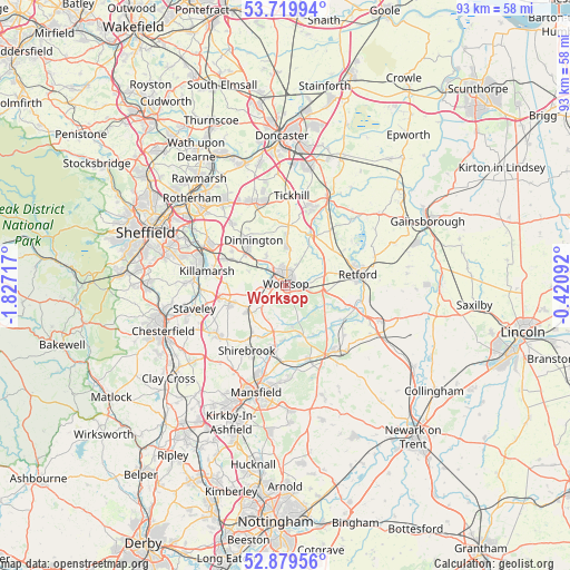
Worksop GPS coordinates[2]
53° 18' 6.552" North, 1° 7' 26.544" West
| Map corner | latitude | longitude |
|---|---|---|
| Upper-left | 53.71994°, | -1.82717° |
| Center: | 53.30182°, | -1.12404° |
| Lower-right: | 52.87956°, | -0.42092° |
| Map W x H: | 93.4×93.4 km | = 58×58mi |
| max Lat: | 60.39635° ⇑33.9% North |
| Worksop: | 53.30182° |
| min Lat: | ⇓66.1% South 34.60088° |
| min Long | Worksop | max Long |
| -7.64133° | -1.12404° | 32.95536° |
| W 64.4%⇐ | ⇒35.6% E |
Elevation
Elevation of Worksop is 46 m = 151 ft, and this is 26.9 m = 88 ft below average elevation for this country.
| Max E: |
515 m = 1690 ft | 60.2% |
| Avg. | 72.9 m = 239 ft | |
| Worksop | 46 m = 151 ft | |
Min E: |
-30 m = -98 ft | 39.8% |
See also: Worksop elevation on elevation.city.
Geographical zone
Worksop is located in North temperate zone (between Tropic of Cancer and the Arctic Circle). Distance of this North polar circle is 1474.6 km =916.3 mi to North.| Distance of | km | miles | from Worksop |
|---|---|---|---|
| North Pole | 4080.5 | 2535.5 | to North |
| Arctic Circle | 1474.6 | 916.3 | to North |
| Tropic Cancer | 3320.7 | 2063.4 | to South |
| Equator | 5926.6 | 3682.6 | to South |


Nearby cities:
15 places around Worksop: (largest is in red/bold)
• Babworth
10 km =6.2 mi,  79°
79°
• Barlborough
11 km =6.8 mi,  261°
261°
• Clowne
9.8 km =6.1 mi,  251°
251°
• Creswell
7.7 km =4.8 mi,  235°
235°
• Dinnington
8.8 km =5.5 mi,  325°
325°
• Elkesley
10.7 km =6.6 mi,  107°
107°
• Hardwick Village
6.2 km =3.9 mi,  120°
120°
• Harthill
9.6 km =6 mi,  279°
279°
• Kiveton Park
9.7 km =6 mi,  296°
296°
• Market Warsop
10.9 km =6.8 mi,  190°
190°
• Todwick
10.5 km =6.5 mi, 303°
• Upper Langwith
9.8 km =6.1 mi,  214°
214°
• Warsop
9.9 km =6.2 mi, 190°
• Whitwell
6.5 km =4 mi, 251°
• Woodsetts
6 km =3.7 mi, 328°
Sources, notices
• [Note1] Compared only with cities in United Kingdom existing in our database
• [Src1] Map data: © OpenStreetMap contributors (CC-BY-SA)
• [Src2] Other city data from geonames.org with taken over terms of usage.
• [Src3] Geographical zone / Annual Mean Temperature by Robert A. Rohde @ Wikipedia
