Woking geodata
Woking (England) is a populated place; located in United Kingdom in Europe/London (GMT+1) time zone. With population of 103,932 people, there are 93 cities with bigger population in this country. Compared to other cities in United Kingdom, 83.6% of cities are located further ↑North; 75.3% of cities are located further ←West and 65.5% of cities have higher elevation than Woking. Note1


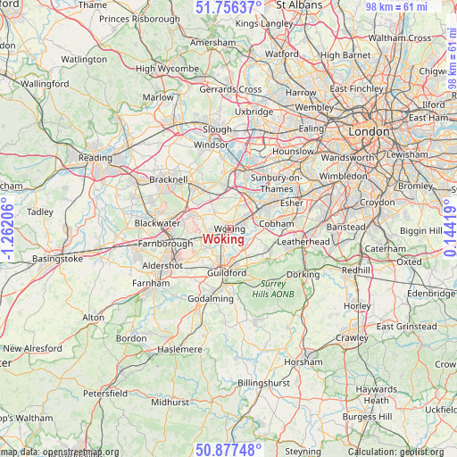
Woking GPS coordinates[2]
51° 19' 8.508" North, 0° 33' 32.148" West
| Map corner | latitude | longitude |
|---|---|---|
| Upper-left | 51.75637°, | -1.26206° |
| Center: | 51.31903°, | -0.55893° |
| Lower-right: | 50.87748°, | 0.14419° |
| Map W x H: | 97.7×97.7 km | = 60.7×60.7mi |
| max Lat: | 60.39635° ⇑83.6% North |
| Woking: | 51.31903° |
| min Lat: | ⇓16.4% South 34.60088° |
| min Long | Woking | max Long |
| -7.64133° | -0.55893° | 32.95536° |
| W 75.3%⇐ | ⇒24.7% E |
Elevation
Elevation of Woking is 39 m = 128 ft, and this is 33.9 m = 111 ft below average elevation for this country.
| Max E: |
515 m = 1690 ft | 65.5% |
| Avg. | 72.9 m = 239 ft | |
| Woking | 39 m = 128 ft | |
Min E: |
-30 m = -98 ft | 34.5% |
See also: Woking elevation on elevation.city.
Geographical zone
Woking is located in North temperate zone (between Tropic of Cancer and the Arctic Circle). Distance of this North polar circle is 1695 km =1053.2 mi to North.| Distance of | km | miles | from Woking |
|---|---|---|---|
| North Pole | 4300.9 | 2672.5 | to North |
| Arctic Circle | 1695 | 1053.2 | to North |
| Tropic Cancer | 3100.2 | 1926.4 | to South |
| Equator | 5706.1 | 3545.6 | to South |


Nearby cities:
15 places around Woking: (largest is in red/bold)
• Addlestone
7.4 km =4.6 mi,  37°
37°
• Byfleet
6.4 km =4 mi,  68°
68°
• Chertsey
8.5 km =5.3 mi,  24°
24°
• Chobham
4.6 km =2.9 mi,  314°
314°
• Fairlands
7.7 km =4.8 mi,  214°
214°
• Knaphill
4 km =2.5 mi,  271°
271°
• Lightwater
8.5 km =5.3 mi,  292°
292°
• Ottershaw
5.3 km =3.3 mi, 24°
• Pirbright
6.9 km =4.3 mi,  243°
243°
• Ripley
5.2 km =3.2 mi,  115°
115°
• Send
4 km =2.5 mi,  146°
146°
• West Byfleet
4.2 km =2.6 mi,  60°
60°
• West Clandon
7.6 km =4.7 mi, 149°
• Weybridge
9 km =5.6 mi,  49°
49°
• Windlesham
8.4 km =5.2 mi, 307°
Sources, notices
• [Note1] Compared only with cities in United Kingdom existing in our database
• [Src1] Map data: © OpenStreetMap contributors (CC-BY-SA)
• [Src2] Other city data from geonames.org with taken over terms of usage.
• [Src3] Geographical zone / Annual Mean Temperature by Robert A. Rohde @ Wikipedia
