Wigan geodata
Wigan (England) is a seat of a second-order administrative division; located in United Kingdom in Europe/London (GMT+1) time zone. With population of 175,405 people, there are 46 cities with bigger population in this country. Compared to other cities in United Kingdom, 70.7% of cities are located further ↓South; 67.5% of cities are located further →East and 70.9% of cities have higher elevation than Wigan. Note1


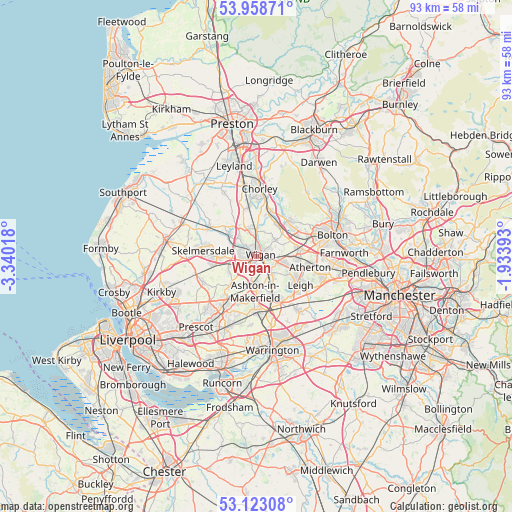
Wigan GPS coordinates[2]
53° 32' 34.656" North, 2° 38' 13.416" West
| Map corner | latitude | longitude |
|---|---|---|
| Upper-left | 53.95871°, | -3.34018° |
| Center: | 53.54296°, | -2.63706° |
| Lower-right: | 53.12308°, | -1.93393° |
| Map W x H: | 92.9×92.9 km | = 57.7×57.7mi |
| max Lat: | 60.39635° ⇑29.3% North |
| Wigan: | 53.54296° |
| min Lat: | ⇓70.7% South 34.60088° |
| min Long | Wigan | max Long |
| -7.64133° | -2.63706° | 32.95536° |
| W 32.5%⇐ | ⇒67.5% E |
Elevation
Elevation of Wigan is 32 m = 105 ft, and this is 40.9 m = 134 ft below average elevation for this country.
| Max E: |
515 m = 1690 ft | 70.9% |
| Avg. | 72.9 m = 239 ft | |
| Wigan | 32 m = 105 ft | |
Min E: |
-30 m = -98 ft | 29.1% |
See also: Wigan elevation on elevation.city.
Geographical zone
Wigan is located in North temperate zone (between Tropic of Cancer and the Arctic Circle). Distance of this North polar circle is 1447.8 km =899.6 mi to North.| Distance of | km | miles | from Wigan |
|---|---|---|---|
| North Pole | 4053.6 | 2518.8 | to North |
| Arctic Circle | 1447.8 | 899.6 | to North |
| Tropic Cancer | 3347.5 | 2080 | to South |
| Equator | 5953.4 | 3699.3 | to South |


Nearby cities:
15 places around Wigan: (largest is in red/bold)
• Abram
4.8 km =3 mi,  142°
142°
• Adlington
8.1 km =5 mi,  14°
14°
• Appley Bridge
6.8 km =4.2 mi,  304°
304°
• Ashton in Makerfield
6.7 km =4.2 mi,  187°
187°
• Bickershaw
5.5 km =3.4 mi,  126°
126°
• Billinge
6.9 km =4.3 mi,  223°
223°
• Blackrod
6.6 km =4.1 mi,  34°
34°
• Golborne
7.8 km =4.8 mi,  159°
159°
• Haigh
7.3 km =4.5 mi, 29°
• Haydock
8.9 km =5.5 mi,  199°
199°
• Hindley
3.7 km =2.3 mi,  106°
106°
• Horwich
8.7 km =5.4 mi,  41°
41°
• Ince-in-Makerfield
1.7 km =1.1 mi, 128°
• Shevington
4.9 km =3 mi,  311°
311°
• Westhoughton
7.5 km =4.7 mi,  84°
84°
Sources, notices
• [Note1] Compared only with cities in United Kingdom existing in our database
• [Src1] Map data: © OpenStreetMap contributors (CC-BY-SA)
• [Src2] Other city data from geonames.org with taken over terms of usage.
• [Src3] Geographical zone / Annual Mean Temperature by Robert A. Rohde @ Wikipedia
