Weston-super-Mare geodata
Weston-super-Mare (England) is a seat of a second-order administrative division; located in United Kingdom in Europe/London (GMT+1) time zone. With population of 82,903 people, there are 122 cities with bigger population in this country. Compared to other cities in United Kingdom, 82.8% of cities are located further ↑North; 74.8% of cities are located further →East and 88.2% of cities have higher elevation than Weston-super-Mare. Note1


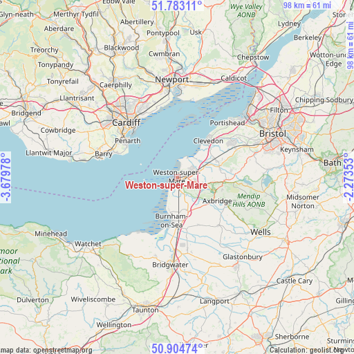
Weston-super-Mare GPS coordinates[2]
51° 20' 45.708" North, 2° 58' 35.94" West
| Map corner | latitude | longitude |
|---|---|---|
| Upper-left | 51.78311°, | -3.67978° |
| Center: | 51.34603°, | -2.97665° |
| Lower-right: | 50.90474°, | -2.27353° |
| Map W x H: | 97.7×97.7 km | = 60.7×60.7mi |
| max Lat: | 60.39635° ⇑82.8% North |
| Weston-super-Mare: | 51.34603° |
| min Lat: | ⇓17.2% South 34.60088° |
| min Long | Weston-super-Ma | max Long |
| -7.64133° | -2.97665° | 32.95536° |
| W 25.2%⇐ | ⇒74.8% E |
Elevation
Elevation of Weston-super-Mare is 13 m = 43 ft, and this is 59.9 m = 197 ft below average elevation for this country.
| Max E: |
515 m = 1690 ft | 88.2% |
| Avg. | 72.9 m = 239 ft | |
| Weston-super-Mare | 13 m = 43 ft | |
Min E: |
-30 m = -98 ft | 11.8% |
See also: Weston-super-Mare elevation on elevation.city.
Geographical zone
Weston-super-Mare is located in North temperate zone (between Tropic of Cancer and the Arctic Circle). Distance of this North polar circle is 1692 km =1051.4 mi to North.| Distance of | km | miles | from Weston-super-Mare |
|---|---|---|---|
| North Pole | 4297.9 | 2670.6 | to North |
| Arctic Circle | 1692 | 1051.4 | to North |
| Tropic Cancer | 3103.2 | 1928.2 | to South |
| Equator | 5709.1 | 3547.5 | to South |


Nearby cities:
15 places around Weston-super-Mare: (largest is in red/bold)
• Banwell
7.7 km =4.8 mi,  104°
104°
• Bleadon
4.6 km =2.9 mi,  154°
154°
• Brent Knoll
10.5 km =6.5 mi,  172°
172°
• East Brent
9.6 km =6 mi,  162°
162°
• Edingworth
8.7 km =5.4 mi, 154°
• Hutton
4 km =2.5 mi,  127°
127°
• Kenn
11.8 km =7.3 mi,  48°
48°
• Kewstoke
2.5 km =1.6 mi,  29°
29°
• Kingston Seymour
9.9 km =6.2 mi, 54°
• Locking
4.6 km =2.9 mi,  108°
108°
• Lympsham
7.1 km =4.4 mi, 167°
• Sandford
10.2 km =6.3 mi, 98°
• St. Georges
5.8 km =3.6 mi,  71°
71°
• Winscombe
10.5 km =6.5 mi, 107°
• Yatton
11.6 km =7.2 mi, 66°
Sources, notices
• [Note1] Compared only with cities in United Kingdom existing in our database
• [Src1] Map data: © OpenStreetMap contributors (CC-BY-SA)
• [Src2] Other city data from geonames.org with taken over terms of usage.
• [Src3] Geographical zone / Annual Mean Temperature by Robert A. Rohde @ Wikipedia
