Wellingborough geodata
Wellingborough (England) is a populated place; located in United Kingdom in Europe/London (GMT+1) time zone. With population of 50,577 people, there are 229 cities with bigger population in this country. Compared to other cities in United Kingdom, 53.9% of cities are located further ↑North; 72.4% of cities are located further ←West and 55.8% of cities have lower elevation than Wellingborough. Note1
Administrative division(s):
- Level 1: England
- Level 2: Northamptonshire
- Level 3: Wellingborough District


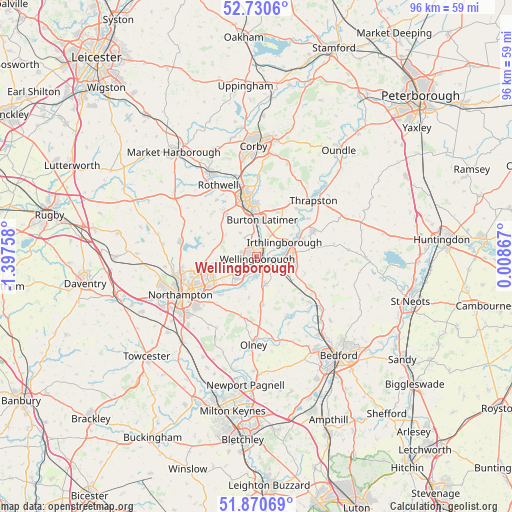
Wellingborough GPS coordinates[2]
52° 18' 9.828" North, 0° 41' 40.056" West
| Map corner | latitude | longitude |
|---|---|---|
| Upper-left | 52.7306°, | -1.39758° |
| Center: | 52.30273°, | -0.69446° |
| Lower-right: | 51.87069°, | 0.00867° |
| Map W x H: | 95.6×95.6 km | = 59.4×59.4mi |
| max Lat: | 60.39635° ⇑53.9% North |
| Wellingborough: | 52.30273° |
| min Lat: | ⇓46.1% South 34.60088° |
| min Long | Wellingborough | max Long |
| -7.64133° | -0.69446° | 32.95536° |
| W 72.4%⇐ | ⇒27.6% E |
Elevation
Elevation of Wellingborough is 70 m = 230 ft, and this is 2.9 m = 10 ft below average elevation for this country.
| Max E: |
515 m = 1690 ft | 44.2% |
| Avg. | 72.9 m = 239 ft | |
| Wellingborough | 70 m = 230 ft | |
Min E: |
-30 m = -98 ft | 55.8% |
See also: Wellingborough elevation on elevation.city.
Geographical zone
Wellingborough is located in North temperate zone (between Tropic of Cancer and the Arctic Circle). Distance of this North polar circle is 1585.7 km =985.3 mi to North.| Distance of | km | miles | from Wellingborough |
|---|---|---|---|
| North Pole | 4191.5 | 2604.5 | to North |
| Arctic Circle | 1585.7 | 985.3 | to North |
| Tropic Cancer | 3209.6 | 1994.4 | to South |
| Equator | 5815.5 | 3613.6 | to South |


Nearby cities:
15 places around Wellingborough: (largest is in red/bold)
• Bozeat
9 km =5.6 mi,  170°
170°
• Burton Latimer
6.9 km =4.3 mi,  9°
9°
• Cogenhoe
9.5 km =5.9 mi,  220°
220°
• Earls Barton
5.7 km =3.5 mi, 224°
• Finedon
5.1 km =3.2 mi,  36°
36°
• Grendon
7.7 km =4.8 mi,  189°
189°
• Higham Ferrers
6.9 km =4.3 mi,  87°
87°
• Irchester
4.1 km =2.5 mi,  125°
125°
• Irthlingborough
6.3 km =3.9 mi,  64°
64°
• Isham
6.1 km =3.8 mi,  354°
354°
• Podington
7.2 km =4.5 mi,  138°
138°
• Rushden
6.5 km =4 mi,  103°
103°
• Stanwick
9.5 km =5.9 mi,  69°
69°
• Sywell
7 km =4.3 mi,  266°
266°
• Wollaston
5.2 km =3.2 mi,  161°
161°
Sources, notices
• [Note1] Compared only with cities in United Kingdom existing in our database
• [Src1] Map data: © OpenStreetMap contributors (CC-BY-SA)
• [Src2] Other city data from geonames.org with taken over terms of usage.
• [Src3] Geographical zone / Annual Mean Temperature by Robert A. Rohde @ Wikipedia
