Watford geodata
Watford (England) is a populated place; located in United Kingdom in Europe/London (GMT+1) time zone. With population of 125,707 people, there are 74 cities with bigger population in this country. Compared to other cities in United Kingdom, 72.6% of cities are located further ↑North; 79% of cities are located further ←West and 60.3% of cities have lower elevation than Watford. Note1


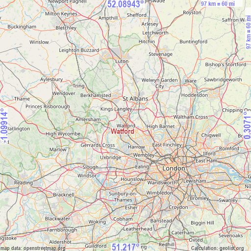
Watford GPS coordinates[2]
51° 39' 19.116" North, 0° 23' 45.672" West
| Map corner | latitude | longitude |
|---|---|---|
| Upper-left | 52.08943°, | -1.09914° |
| Center: | 51.65531°, | -0.39602° |
| Lower-right: | 51.217°, | 0.3071° |
| Map W x H: | 97×97 km | = 60.3×60.3mi |
| max Lat: | 60.39635° ⇑72.6% North |
| Watford: | 51.65531° |
| min Lat: | ⇓27.4% South 34.60088° |
| min Long | Watford | max Long |
| -7.64133° | -0.39602° | 32.95536° |
| W 79%⇐ | ⇒21% E |
Elevation
Elevation of Watford is 77 m = 253 ft, and this is 4.1 m = 13 ft above average elevation for this country.
| Max E: |
515 m = 1690 ft | 39.7% |
| Watford | 77 m 253 ft | |
| Avg. | 72.9 m = 239 ft | |
Min E: |
-30 m = -98 ft | 60.3% |
See also: Watford elevation on elevation.city.
Geographical zone
Watford is located in North temperate zone (between Tropic of Cancer and the Arctic Circle). Distance of this North polar circle is 1657.6 km =1030 mi to North.| Distance of | km | miles | from Watford |
|---|---|---|---|
| North Pole | 4263.5 | 2649.2 | to North |
| Arctic Circle | 1657.6 | 1030 | to North |
| Tropic Cancer | 3137.6 | 1949.6 | to South |
| Equator | 5743.5 | 3568.8 | to South |


Nearby cities:
15 places around Watford: (largest is in red/bold)
• Abbots Langley
5.8 km =3.6 mi,  345°
345°
• Borehamwood
8.2 km =5.1 mi,  90°
90°
• Bushey
2.8 km =1.7 mi,  118°
118°
• Chorleywood
8.1 km =5 mi,  269°
269°
• Elstree
7 km =4.3 mi,  103°
103°
• Greenhill
8.9 km =5.5 mi,  153°
153°
• Harefield
8.5 km =5.3 mi,  226°
226°
• Kings Langley
7.5 km =4.7 mi,  330°
330°
• Maple Cross
8.4 km =5.2 mi,  246°
246°
• Pinner
6.9 km =4.3 mi,  172°
172°
• Radlett
6.3 km =3.9 mi,  57°
57°
• Rickmansworth
5.9 km =3.7 mi, 252°
• Sarratt
7.5 km =4.7 mi,  295°
295°
• Shenley
8.9 km =5.5 mi, 63°
• Stanmore
7 km =4.3 mi,  128°
128°
Sources, notices
• [Note1] Compared only with cities in United Kingdom existing in our database
• [Src1] Map data: © OpenStreetMap contributors (CC-BY-SA)
• [Src2] Other city data from geonames.org with taken over terms of usage.
• [Src3] Geographical zone / Annual Mean Temperature by Robert A. Rohde @ Wikipedia
