Warden geodata
Warden (England) is a seat of a third-order administrative division; located in United Kingdom in Europe/London (GMT+1) time zone. In our database, there are 4977 cities with bigger population. Compared to other cities in United Kingdom, 86.5% of cities are located further ↓South; 57.6% of cities are located further →East and 61% of cities have higher elevation than Warden. Note1


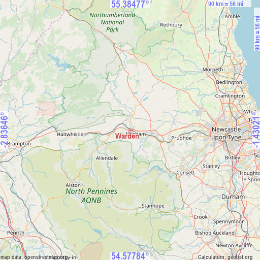
Warden GPS coordinates[2]
54° 58' 59.988" North, 2° 7' 59.988" West
| Map corner | latitude | longitude |
|---|---|---|
| Upper-left | 55.38477°, | -2.83646° |
| Center: | 54.98333°, | -2.13333° |
| Lower-right: | 54.57784°, | -1.43021° |
| Map W x H: | 89.7×89.7 km | = 55.7×55.7mi |
| max Lat: | 60.39635° ⇑13.5% North |
| Warden: | 54.98333° |
| min Lat: | ⇓86.5% South 34.60088° |
| min Long | Warden | max Long |
| -7.64133° | -2.13333° | 32.95536° |
| W 42.4%⇐ | ⇒57.6% E |
Elevation
Elevation of Warden is 45 m = 148 ft, and this is 27.9 m = 92 ft below average elevation for this country.
| Max E: |
515 m = 1690 ft | 61% |
| Avg. | 72.9 m = 239 ft | |
| Warden | 45 m = 148 ft | |
Min E: |
-30 m = -98 ft | 39% |
See also: United Kingdom elevation on elevation.city.
Geographical zone
Warden is located in North temperate zone (between Tropic of Cancer and the Arctic Circle). Distance of this North polar circle is 1287.6 km =800.1 mi to North.| Distance of | km | miles | from Warden |
|---|---|---|---|
| North Pole | 3893.5 | 2419.3 | to North |
| Arctic Circle | 1287.6 | 800.1 | to North |
| Tropic Cancer | 3507.7 | 2179.6 | to South |
| Equator | 6113.6 | 3798.8 | to South |


Nearby cities:
15 places around Warden: (largest is in red/bold)
• Acomb
1.7 km =1.1 mi,  53°
53°
• Allendale Town
12.4 km =7.7 mi,  219°
219°
• Bardon Mill
13.4 km =8.3 mi,  266°
266°
• Birtley
11.6 km =7.2 mi,  344°
344°
• Corbridge
7.4 km =4.6 mi,  98°
98°
• Haydon Bridge
7.3 km =4.5 mi,  262°
262°
• Healey
13 km =8.1 mi,  124°
124°
• Hexham
2.4 km =1.5 mi,  128°
128°
• Horsley
18.1 km =11.2 mi,  90°
90°
• Humshaugh
6.1 km =3.8 mi,  2°
2°
• Prudhoe
18.1 km =11.2 mi, 97°
• Riding Mill
10.9 km =6.8 mi,  110°
110°
• Slaley
9.9 km =6.2 mi,  141°
141°
• Stocksfield
15.4 km =9.6 mi, 108°
• Wall
1.9 km =1.2 mi, 0°
Sources, notices
• [Note1] Compared only with cities in United Kingdom existing in our database
• [Src1] Map data: © OpenStreetMap contributors (CC-BY-SA)
• [Src2] Other city data from geonames.org with taken over terms of usage.
• [Src3] Geographical zone / Annual Mean Temperature by Robert A. Rohde @ Wikipedia
