Walton-on-Thames geodata
Walton-on-Thames (England) is a populated place; located in United Kingdom in Europe/London (GMT+1) time zone. With population of 22,834 people, there are 523 cities with bigger population in this country. Compared to other cities in United Kingdom, 81.4% of cities are located further ↑North; 78.6% of cities are located further ←West and 82.8% of cities have higher elevation than Walton-on-Thames. Note1


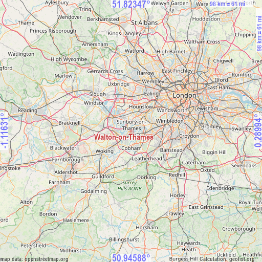
Walton-on-Thames GPS coordinates[2]
51° 23' 12.408" North, 0° 24' 47.484" West
| Map corner | latitude | longitude |
|---|---|---|
| Upper-left | 51.82347°, | -1.11631° |
| Center: | 51.38678°, | -0.41319° |
| Lower-right: | 50.94588°, | 0.28994° |
| Map W x H: | 97.6×97.6 km | = 60.6×60.6mi |
| max Lat: | 60.39635° ⇑81.4% North |
| Walton-on-Thames: | 51.38678° |
| min Lat: | ⇓18.6% South 34.60088° |
| min Long | Walton-on-Thame | max Long |
| -7.64133° | -0.41319° | 32.95536° |
| W 78.6%⇐ | ⇒21.4% E |
Elevation
Elevation of Walton-on-Thames is 18 m = 59 ft, and this is 54.9 m = 180 ft below average elevation for this country.
| Max E: |
515 m = 1690 ft | 82.8% |
| Avg. | 72.9 m = 239 ft | |
| Walton-on-Thames | 18 m = 59 ft | |
Min E: |
-30 m = -98 ft | 17.2% |
See also: United Kingdom elevation on elevation.city.
Geographical zone
Walton-on-Thames is located in North temperate zone (between Tropic of Cancer and the Arctic Circle). Distance of this North polar circle is 1687.5 km =1048.6 mi to North.| Distance of | km | miles | from Walton-on-Thames |
|---|---|---|---|
| North Pole | 4293.4 | 2667.8 | to North |
| Arctic Circle | 1687.5 | 1048.6 | to North |
| Tropic Cancer | 3107.8 | 1931.1 | to South |
| Equator | 5713.7 | 3550.3 | to South |


Nearby cities:
15 places around Walton-on-Thames: (largest is in red/bold)
• Addlestone
5.8 km =3.6 mi,  252°
252°
• Ashford
5.9 km =3.7 mi,  328°
328°
• Byfleet
6.6 km =4.1 mi,  218°
218°
• Chertsey
6.6 km =4.1 mi,  271°
271°
• Cobham
6.3 km =3.9 mi,  178°
178°
• East Molesey
4.6 km =2.9 mi,  73°
73°
• Esher
3.7 km =2.3 mi,  120°
120°
• Feltham
6.6 km =4.1 mi,  359°
359°
• Hampton
4.4 km =2.7 mi,  47°
47°
• Hinchley Wood
5.4 km =3.4 mi,  104°
104°
• Shepperton
2.7 km =1.7 mi,  291°
291°
• Sunbury-on-Thames
2 km =1.2 mi,  349°
349°
• Thames Ditton
5.1 km =3.2 mi,  86°
86°
• West Molesey
2.7 km =1.7 mi,  57°
57°
• Weybridge
3.6 km =2.2 mi,  242°
242°
Sources, notices
• [Note1] Compared only with cities in United Kingdom existing in our database
• [Src1] Map data: © OpenStreetMap contributors (CC-BY-SA)
• [Src2] Other city data from geonames.org with taken over terms of usage.
• [Src3] Geographical zone / Annual Mean Temperature by Robert A. Rohde @ Wikipedia
