Walford geodata
Walford (England) is a seat of a third-order administrative division; located in United Kingdom in Europe/London (GMT+1) time zone. In our database, there are 4977 cities with bigger population. Compared to other cities in United Kingdom, 65.4% of cities are located further ↑North; 67.1% of cities are located further →East and 68.3% of cities have higher elevation than Walford. Note1


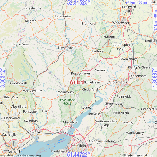
Walford GPS coordinates[2]
51° 52' 59.988" North, 2° 36' 0" West
| Map corner | latitude | longitude |
|---|---|---|
| Upper-left | 52.31525°, | -3.30312° |
| Center: | 51.88333°, | -2.6° |
| Lower-right: | 51.44722°, | -1.89687° |
| Map W x H: | 96.5×96.5 km | = 60×60mi |
| max Lat: | 60.39635° ⇑65.4% North |
| Walford: | 51.88333° |
| min Lat: | ⇓34.6% South 34.60088° |
| min Long | Walford | max Long |
| -7.64133° | -2.6° | 32.95536° |
| W 32.9%⇐ | ⇒67.1% E |
Elevation
Elevation of Walford is 35 m = 115 ft, and this is 37.9 m = 124 ft below average elevation for this country.
| Max E: |
515 m = 1690 ft | 68.3% |
| Avg. | 72.9 m = 239 ft | |
| Walford | 35 m = 115 ft | |
Min E: |
-30 m = -98 ft | 31.7% |
See also: United Kingdom elevation on elevation.city.
Geographical zone
Walford is located in North temperate zone (between Tropic of Cancer and the Arctic Circle). Distance of this North polar circle is 1632.3 km =1014.3 mi to North.| Distance of | km | miles | from Walford |
|---|---|---|---|
| North Pole | 4238.2 | 2633.5 | to North |
| Arctic Circle | 1632.3 | 1014.3 | to North |
| Tropic Cancer | 3163 | 1965.4 | to South |
| Equator | 5768.9 | 3584.6 | to South |


Nearby cities:
15 places around Walford: (largest is in red/bold)
• Cinderford
9.6 km =6 mi,  133°
133°
• Coleford
9.8 km =6.1 mi,  185°
185°
• Crow Hill
8.2 km =5.1 mi,  40°
40°
• Drybrook
6.5 km =4 mi,  118°
118°
• Lea
7.1 km =4.4 mi,  74°
74°
• Linton
8.5 km =5.3 mi,  56°
56°
• Lydbrook
5.3 km =3.3 mi,  163°
163°
• Marstow
3.9 km =2.4 mi,  241°
241°
• Mitcheldean
7.9 km =4.9 mi,  105°
105°
• Pencoyd
8.8 km =5.5 mi,  309°
309°
• Ross on Wye
4.4 km =2.7 mi,  31°
31°
• Ruardean
4.6 km =2.9 mi, 132°
• Sellack
7.8 km =4.8 mi,  342°
342°
• Weston under Penyard
5.1 km =3.2 mi, 57°
• Whitchurch
5.1 km =3.2 mi,  222°
222°
Sources, notices
• [Note1] Compared only with cities in United Kingdom existing in our database
• [Src1] Map data: © OpenStreetMap contributors (CC-BY-SA)
• [Src2] Other city data from geonames.org with taken over terms of usage.
• [Src3] Geographical zone / Annual Mean Temperature by Robert A. Rohde @ Wikipedia
