Wakefield geodata
Wakefield (England) is a seat of a second-order administrative division; located in United Kingdom in Europe/London (GMT+1) time zone. With population of 78,978 people, there are 128 cities with bigger population in this country. Compared to other cities in United Kingdom, 73.3% of cities are located further ↓South; 55.5% of cities are located further ←West and 57.5% of cities have higher elevation than Wakefield. Note1


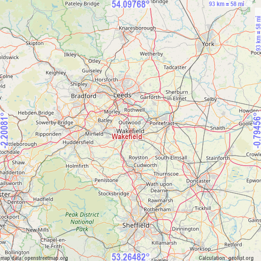
Wakefield GPS coordinates[2]
53° 40' 59.916" North, 1° 29' 51.648" West
| Map corner | latitude | longitude |
|---|---|---|
| Upper-left | 54.09768°, | -2.20081° |
| Center: | 53.68331°, | -1.49768° |
| Lower-right: | 53.26482°, | -0.79456° |
| Map W x H: | 92.6×92.6 km | = 57.5×57.5mi |
| max Lat: | 60.39635° ⇑26.7% North |
| Wakefield: | 53.68331° |
| min Lat: | ⇓73.3% South 34.60088° |
| min Long | Wakefield | max Long |
| -7.64133° | -1.49768° | 32.95536° |
| W 55.5%⇐ | ⇒44.5% E |
Elevation
Elevation of Wakefield is 50 m = 164 ft, and this is 22.9 m = 75 ft below average elevation for this country.
| Max E: |
515 m = 1690 ft | 57.5% |
| Avg. | 72.9 m = 239 ft | |
| Wakefield | 50 m = 164 ft | |
Min E: |
-30 m = -98 ft | 42.5% |
See also: Wakefield elevation on elevation.city.
Geographical zone
Wakefield is located in North temperate zone (between Tropic of Cancer and the Arctic Circle). Distance of this North polar circle is 1432.1 km =889.9 mi to North.| Distance of | km | miles | from Wakefield |
|---|---|---|---|
| North Pole | 4038 | 2509.1 | to North |
| Arctic Circle | 1432.1 | 889.9 | to North |
| Tropic Cancer | 3363.1 | 2089.7 | to South |
| Equator | 5969 | 3709 | to South |


Nearby cities:
15 places around Wakefield: (largest is in red/bold)
• Crigglestone
5 km =3.1 mi,  204°
204°
• Crofton
5.4 km =3.4 mi,  123°
123°
• Dewsbury
8.7 km =5.4 mi,  275°
275°
• Horbury
4.8 km =3 mi,  238°
238°
• Kirkhamgate
4.2 km =2.6 mi,  299°
299°
• Lofthouse
5.1 km =3.2 mi,  0°
0°
• Methley
8 km =5 mi,  50°
50°
• Middlestown
7.5 km =4.7 mi, 241°
• Normanton
5.6 km =3.5 mi,  70°
70°
• Notton
8 km =5 mi,  167°
167°
• Ossett
5.4 km =3.4 mi,  265°
265°
• Ryhill
8.9 km =5.5 mi,  139°
139°
• Sharlston
5.8 km =3.6 mi,  105°
105°
• Walton
4.4 km =2.7 mi,  151°
151°
• Woolley
7.9 km =4.9 mi,  188°
188°
Sources, notices
• [Note1] Compared only with cities in United Kingdom existing in our database
• [Src1] Map data: © OpenStreetMap contributors (CC-BY-SA)
• [Src2] Other city data from geonames.org with taken over terms of usage.
• [Src3] Geographical zone / Annual Mean Temperature by Robert A. Rohde @ Wikipedia
