Thornhill geodata
Thornhill (Scotland) is a populated place; located in United Kingdom in Europe/London (GMT+1) time zone. With population of 540 people, there are 4763 cities with bigger population in this country. Compared to other cities in United Kingdom, 95.5% of cities are located further ↓South; 90% of cities are located further →East and 64% of cities have higher elevation than Thornhill. Note1


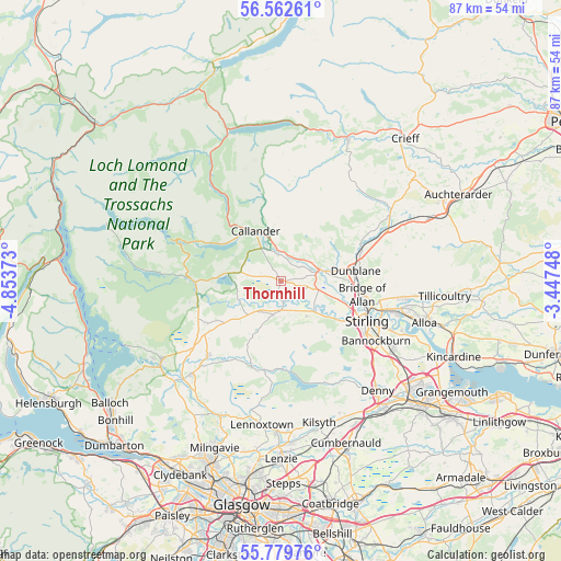
Thornhill GPS coordinates[2]
56° 10' 23.448" North, 4° 9' 2.16" West
| Map corner | latitude | longitude |
|---|---|---|
| Upper-left | 56.56261°, | -4.85373° |
| Center: | 56.17318°, | -4.1506° |
| Lower-right: | 55.77976°, | -3.44748° |
| Map W x H: | 87×87 km | = 54.1×54.1mi |
| max Lat: | 60.39635° ⇑4.5% North |
| Thornhill: | 56.17318° |
| min Lat: | ⇓95.5% South 34.60088° |
| min Long | Thornhill | max Long |
| -7.64133° | -4.1506° | 32.95536° |
| W 10%⇐ | ⇒90% E |
Elevation
Elevation of Thornhill is 41 m = 135 ft, and this is 31.9 m = 105 ft below average elevation for this country.
| Max E: |
515 m = 1690 ft | 64% |
| Avg. | 72.9 m = 239 ft | |
| Thornhill | 41 m = 135 ft | |
Min E: |
-30 m = -98 ft | 36% |
See also: United Kingdom elevation on elevation.city.
Geographical zone
Thornhill is located in North temperate zone (between Tropic of Cancer and the Arctic Circle). Distance of this North polar circle is 1155.3 km =717.9 mi to North.| Distance of | km | miles | from Thornhill |
|---|---|---|---|
| North Pole | 3761.2 | 2337.1 | to North |
| Arctic Circle | 1155.3 | 717.9 | to North |
| Tropic Cancer | 3640 | 2261.8 | to South |
| Equator | 6245.9 | 3881 | to South |


Nearby cities:
15 places around Thornhill: (largest is in red/bold)
• Aberfoyle
14.5 km =9 mi,  272°
272°
• Balfron
16.4 km =10.2 mi,  224°
224°
• Bannockburn
17.5 km =10.9 mi,  121°
121°
• Braco
19.6 km =12.2 mi,  58°
58°
• Bridge of Allan
12.8 km =8 mi,  99°
99°
• Buchlyvie
11 km =6.8 mi,  234°
234°
• Callander
8.9 km =5.5 mi,  332°
332°
• Doune
6.3 km =3.9 mi,  72°
72°
• Dunblane
11.7 km =7.3 mi,  81°
81°
• Fallin
18.6 km =11.6 mi,  114°
114°
• Gargunnock
6.8 km =4.2 mi,  142°
142°
• Kippen
5.3 km =3.3 mi,  193°
193°
• Menstrie
18.5 km =11.5 mi, 97°
• Stirling
14.5 km =9 mi, 114°
• Tullibody
19.8 km =12.3 mi, 102°
Sources, notices
• [Note1] Compared only with cities in United Kingdom existing in our database
• [Src1] Map data: © OpenStreetMap contributors (CC-BY-SA)
• [Src2] Other city data from geonames.org with taken over terms of usage.
• [Src3] Geographical zone / Annual Mean Temperature by Robert A. Rohde @ Wikipedia
